Advertisement
Published: April 4th 2009

 Madaba - Mosaic
St George's Greek Orthodox church07h00 came surprisingly early. I know it happens at the same time each day but I'd once again found it difficult to sleep on the small mountain that purported to be a pillow. Clearly though, after having got rid of the pillow, I must have slept as the alarm clock was waking me up.
After taking a shower and dressing, I packed my rucksack and headed down to breakfast. Not good - again. This time, the bread rolls were like bullets, but still, I dined on orange juice, coffee and bread - but drew a line at warm milk on the cereal!
Returning to my room, I packed my washing kit and headed down to reception to checkout.
At 08h15, we climbed into the bus and headed off for the first stop of the day.
Mosaics and Moses
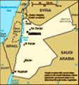
About an hour after leaving Amman, we arrived on a large building site known as Madaba. Making our way along unmade roads, our bus pulled into the car park and we descended into the sun.
Madaba is the most important Christian centre in Jordan and is a shining example of how Christian and Muslim
can live together. Historically,
this Moabite town was one of those divided amongst the twelve tribes of Israel. It changed hands several times through history until the middle of the 8th century when the town was devastated by an earthquake and abandoned. In the late 19th century, the town was again becoming settled, at which point, the now famous mosaics were found. One such mosaic is a map of the Holy Land which, when news reached Europe of its discovery in 1897, brought about a keen archaeological presence, continuing today.
Walking through the town, we headed for the Greek Orthodox Church of St. George to view this famous map. Unearthed in 1884, it was actually put together in 560 and depicts 157 Biblical sites in the Middle East, some unknown at the time of rediscovery. The mosaic is some 40' long and 18' wide and built from over two million pieces. Oh, and spectacular!
Returning to the bus, we drove a short distance, up hill, until we came to a spectacular view. This was Mount Nebo. Both the Old Testament and the Koran tell of Moses being commanded to go to Mount Nebo in Moab and to view the land of Canaan,
which will be given to the Israelites. However, Moses will not enter the Promised Land but die on Mount Nebo. There's a little museum on the top which, although contains some pottery, is mainly displaying maps from the different ages affecting Mount Nebo. Climbing the mountain, the view down into the Jordan Valley across to the Dead Sea is breathtaking. With desert all around, a little strip of blue is just visible as is the great rip in the Earth's crust which is the Jordan Valley.
Taking the King's Highway to Karak
Settling back down in our seats, we had a few hours to kill on our journey south. There are several roads heading in our direction, but we had decided to follow a road that has been in continuous use for over 3000 years. Known as the King's Highway or the Road of the Sultan, the road has been followed by the Israelites
en route to the promised land, the traders making their way to and from Petra, pilgrims heading for Moses' memorial on Mount Nebo, Crusaders heading to their castles and Muslims on their pilgrimage to Mecca. A well used road and now history was being made
Moses
"Go up unto Mount Nebo in Moab across from Jericho and view Canaan, the land I am giving the Israelites as their own possesion. There on the mountain that you have climbed you will die." because we were using it!
The journey south along the road took us through some unbelievably beautiful desert scenery. Stunning views and twisting roads took us down to the river before ascending back up the other side and on to the top. Barren rocks and sand occasionally interspersed with green oasis where the water flowed close enough to the surface to support plant life.
At 13h30, we eventually pulled into Karak, roughly a third of the way between Amman and Petra. Just before be descended into the city, our driver stopped so that we could take photos of the imposing Crusader castle. Occupying the entire ridge, the city has encroached into the castle but nevertheless, it still dominates the skyline.
First things first - we had lunch, taking salads and meat balls before heading off into the castle. This was very different to that of Ajlun, which was built in the Islamic style. Karak, however, was manned, not only by soldiers, but by their families too. Consequently, it is much bigger than Ajlun.
Karak is an ancient city laying on the caravan route between Egypt and Syria. It is also mentioned several times in the Bible.
The castle however, was not built until the early 12th century by the Crusaders. At this time, Christians and Muslims lived together in peace until the castle passed into the hands of the French Crusaders. Intensely disliked by Salah Ad-Din, the French Crusaders were defeated by the Islamic armies and their leader executed. Sadly, this was the beginning of the end for the Crusaders and the castle fell into disrepair in the late 13th Century.
The castle was “rediscovered” in the early 19th century by the same gentleman who “rediscovered” Petra and excavations are still continuing. Standing on the walls, it is easy to see why this location was chosen as the views over the surrounding countryside meant that no one could approach in secret.
That evening saw us in a deserted village hanging onto the side of the Jordan Valley. There, we had simple accommodation, simple food but good company.
Advertisement
Tot: 0.086s; Tpl: 0.015s; cc: 13; qc: 30; dbt: 0.0344s; 1; m:domysql w:travelblog (10.17.0.13); sld: 1;
; mem: 1.1mb