Manx Geography, Isle of Man Geography
Advertisement
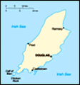
Location: Western Europe, island in the Irish Sea, between Great Britain and Ireland
Geographic coordinates: 54 15 N, 4 30 W
Map references: Europe
Area: Total: 572 sq km land: 572 sq km water: 0 sq km
Area - comparative: Slightly more than three times the size of Washington, DC
Land boundaries: 0 km
Coastline: 160 km
Maritime claims: Territorial sea: 12 nm exclusive fishing zone: 12 nm
Climate: Temperate; cool summers and mild winters; overcast about one-third of the time
Terrain: Hills in north and south bisected by central valley
Elevation extremes: Lowest point: Irish Sea 0 m highest point: Snaefell 621 m
Natural resources: None
Land use: Arable land: 9% permanent crops: 0% other: 91% (permanent pastures, forests, mountain, and heathland) (2002)
Irrigated land: 0 sq km (1998 est.)
Natural hazards: NA
Environment - current issues: Waste disposal (both household and industrial); transboundary air pollution
Environment - international agreements:
Geography - note: One small islet, the Calf of Man, lies to the southwest, and is a bird sanctuary
Advertisement
The information here has been derived from Public Domain Sources such as the CIA World Factbook. No liability can be taken for any inaccuracies.
Tot: 0.036s; Tpl: 0.007s; cc: 6; qc: 6; dbt: 0.0085s; 1; m:domysql w:travelblog (10.17.0.13); sld: 1;
; mem: 1.1mb
 Part of the Norwegian Kingdom of the Hebrides until the 13th century when it was ceded to Scotland, the isle came under the British crown in 1765. Current concerns include reviving the almost extinct Manx Gaelic language....