Advertisement

 Dublin park
Great day, great park, great person. Pity about the photographer!!This is the 2nd ‘episode’ in another of 'our' travel experiences.
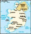
The collective ‘episodes’ describe our journey from our arrival in London (2nd week of June) and across the 'ditch' to Ireland for a few weeks before a return home in mid July. This ‘episode’ describes our few days in Dublin, and our foray westwards and into Northern Ireland (Great Britain) before meandering down the rugged and wild west coast of Ireland.
As always, if you want to 'see' more detail in an accompanying picture, click it to enlarge. We've attached a few pics that give you a flavour of our journey, and some 'flow over' past the dialogue.
Dublin.
The end of the first 'episode' had us arriving latish on Sunday into Dublin sunshine; which to that date had been a rarity.
It appears that summer may have 'arrived', as we've not again experienced rain. Now, it is either days of dark gloomy clouds, or bright clouds and sunshine.
As indicated, we'd not planned to be anywhere. Rather, just head in a direction that sounded appealing; perhaps largely staying in the less urban areas. That agenda was changed when in

 Dublin streetscape
Many buildings in Dublin have characterCork pursuing Judy's family tree we found access to records only available in Dublin. So, we pre-booked 2 days in Dublin.
But, we were not dismayed at Dublin. We found it a lively city with a host of interesting attributes. And, as it's not a megopolis it is (relatively) easily navigated. That said, we relied in the public transport. The city fathers have adopted a dual strategy for commuting. First, there are radial toll roads to an inner ring (
about 10k from the centre). The roads within the ring are car UNfriendly. And, car parking has been privatised (
ie no street parking except in some side streets that are residential, and then only one car permit to a residence). Many roads have been given over to trams or buses. There is an adequate rail network servicing areas beyond the inner ring. A satellite town has been developed at the urban fringe, serviced by high speed tram and buses. The result is a park'n'ride and very people friendly city centre.
We discovered that many Irish 'civil' records were destroyed during the independence conflicts in the early 20th century. Fortunately, Catholic parish records remain as the dominant records for family

 Irish streetscape at 10:30pm
Note the sky at 10:30pm. This is a popular tourist area in the 'old' quarterhistory. We learnt that in the 1970's, the government wanted to 'protect' those records, as many were stored in parish churches with dubious storage standards. Apparently the Catholic Church claimed
the records belong to us, this is just another power grab. The outcome was that the records were loaned to Dublin Archives for the sole purpose of filming on microfilm (
and undertaken only by Catholics). The filming is quality is 'ordinary' and (sadly) haphazard. We also found the cursive script of the parish priest often a challenge to decipher.
Dublin was too interesting (for us) to remain entirely ensconced within the musty old records. We learned that Dublin was a major Viking town and some evidence remains to show their endeavours. But, by far the most interesting were the Norman built structures, of which the city has made into a user friendly 'tourist' area. That said, the rest of the (largish) city centre is still very accessible, steeped in history, and well serviced with cafe's, pubs & restaurants. Do you get the feeling we liked our time here? In fact, we stayed on another day to further enjoy.
Thursday - westwards.
Continuing our journey, we decided

 Ireland
This typifies the Midland countrysideto head westwards via the lesser roads. Though fast, a toll road doesn't 'engage' with the local identity. Once away from the peri-urban, we were in an entirely different landscape. The rolling hills, green pastures, tree lined fencelines, small villages, and windy roads in patchy sunshine made for idyllic travel. We found a radio station with an eclectic mix of bright cheery classical, traditional Irish music, late night jazz, etc. The music, the patchy sunshine, and the landscape all melded to make for idyllic travel. We had to pinch ourselves to ensure it wasn't a dream.
As we progressed further west we entered the Midlands, renowned mainly for the plethora of small lakes and waterways. To us, it was just beautiful scenery and the people we spoke to were just as friendly as we'd encountered elsewhere. We stopped for some lunch and the decoration, ambience and approach by the staff reminded us so much of that portrayed in a period Irish movie - except we were actually experiencing it here and now!!!
With the day drawing towards mealtime, it was time to find digs. While parked beside a bubbling stream, with butterflies and dragonflies for company, we trawled
the internet for a place to stay.
Drumshanbo, a wee town not far from Sligo, offered a great deal. But, for dinner we felt Carrick-on-Shannon was a better bet. After many a pint and a huge (single serve) steak, with potato served in 4 dfferent styles (
chips, mash, buttery dauphine with chives & bacon, and small jacket; the Irish love their spuds!!!), it felt odd to be driving back to our digs at 9:30pm in evening sun (
sunset is around 10:30). Fortunately, the Irish have a quite different view about drink driving than Australia.
Friday - into Great Britain.
Though we'd not planned to go to Northern Ireland, Judy wanted to visit. She asked, if they have
IRL on the number plates in Ireland, do they have
IRA on the other side?
The border is close to Drumshanbo, and the closest GB town is Enniskillen. We spent the day in and around here, so this also was where we bedded for the night.
A little history...
When the British imposed themselves on Ireland, the Irish are said to have largely comprised warring tribes. Long in political control but never really in charge of
the larger landscape, in the late 18th century the British 'gave' large tracts of land to their wealthy aristocracy who were landless. This act, known in Ireland as
the Plantation, resulted in the domestication of the landscape according to British traditions/cultures. Each of the aristocrats built huge mansions on their large estates. Most of the mansions on the GB side are in the hands of the National Trust (
in Ireland the large estates were subdivided for farming and the mansions now private homes on a couple of acres).
With membership to the Queensland National Trust, we have access to these stately homes. The sheer grandeur of the mansions and the unbelievable wealth then displayed is eye opening;
Oh, how the elite lived!!! But, it was the landscaped gardens around the mansions and rolling pastures and woodlands that most appealed. For whatever reason, the integrity of the estates we viewed here appear more intact (
and representative of that past era) than those we'd seen in England.
Saturday - further north.
We decided to head north and west to return to the Republic of Ireland in the region known as Donegal. But, after another beautiful day of sunshine,
and wonderful walks in (1) the town of Omagh aside the River Strule, and (2) in the woods aside the River Mourne at Sion Mills, we decided to stay the night at (London)Derry. Sion Mills is named from the lace making mill (one of many across Ireland) that in the 19th century introduced industrialisation across the landscape.
The Brits impose Londonderry, but the locals (
and especially the Irish nationalists) refer to it as Derry. We were in two thoughts as to whether we'd go there or back to R. Ireland, but we're glad we did. What a great city. Smallish, well organised, clean and tidy and very pretty. Derry is on the River Foyle (
the same river as R Strule, and R Mourne - we don't know why the name changes over such short distances). The river here is quite wide as it meets a protected harbour from the Atlantic ocean. Because of the protected harbour, the (city) site on a hill giving a commanding view appealed to (1st), Vikings, (2nd) Scots, (3rd) Normans and later the British. Still a walled city, the centre is dynamic and largely pedestrianised.
Sunday, and back to R. Ireland.
After
a good wander around Derry, we left around noon and headed to the Glenveagh National Park (and Glenveagh Castle) via Letterkenny. What started out as a lovely sunny morn had deteriorated by 2pm to dark clouds and drizzle. Though elevated, the NP comprises peat bogs, mossy grasslands and a heap of granite boulders strewn across the treeless hills. The Castle sits on a Lough (Gaelic for lake) which rests in a natural geological faultline. The steep hillsides around the Lough impose in a broody sort of way. Despite the drizzle, we decided the 3km walk to the Castle a necessity to address our recent beer indulgences. It was invigorating and good.
In contrast to the harsh and uninviting surroundings, the castle owners had - in the 2th century - developed a magnificent garden. We wondered why anyone would want to 'develop' a castle and parkland in such a remote and otherwise hostile environment.
We continued on past the Muckish Mountains and the iconic Errigal towards the Rosses - a stretch of wild coastline. Elsewhere, Irish signs are in Gaelic with English subtitles. Here, the subtitles were missing. Trying to match the English name to a Gaelic one needs
more than deciphering skill. For example,
Ailt na Girrcheaghe = Agnagary. After a bit of toing and froing, we found some digs and enjoyed a most wonderful meal of local shellfish and seafood.
Monday and a rallycross practice.
The Rosses - a part of the Donegal County coastline of North-West Ireland - is a scenically stunning coastline of bays, small islands, beaches, grassy windswept sandhills, rocky headlands, and largely barren of trees. Instead of trees are so many granite outcrops and countless small lough's. Because of the rocky landform, the road is but one and a bit car widths, undulates over all sorts of bumps, twists and turns around boulders and lakes, such that even at 40kph one feels like a rally car driver.
A particularly high and prominant headland (Slieve) juts into the Atlantic and near Killybegs at Carrigan Head to expose some massive cliffs - claimed by locals to be the highest coastal cliffs of Europe. With a range of rock colorations they are spectacularly impressive.
We ended the day at Sligo, the provincial home of William Butler Yeats.
- - - -
Given the crappy weather of the first week

 'Rosses' road
This is the 'main' road between Annagary & Burtonportor so, the lack of rain and moderate patches of sunshine has been great.
Within relatively small distances (
for Australian standards), we have experienced a wide range of countryside types; brought about be differing soil types. Yet, several aspects hold true; the villages are quaintly condensed into a small area, the houses will have no trees around them, the rural fencelines are usually stone walls (either high or low), the grass is really bright green, and every Irish person we've met is friendly.
Cheers
ps. The third in this trilogy can be found
#3 here .
Advertisement
Tot: 0.222s; Tpl: 0.02s; cc: 10; qc: 28; dbt: 0.0409s; 1; m:domysql w:travelblog (10.17.0.13); sld: 1;
; mem: 1.1mb


