Andorran Geography, Andorra Geography
Advertisement
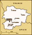
Location: Southwestern Europe, between France and Spain
Geographic coordinates: 42 30 N, 1 30 E
Map references: Europe
Area: Total: 468 sq km land: 468 sq km water: 0 sq km
Area - comparative: 2.5 times the size of Washington, DC
Land boundaries: Total: 120.3 km border countries: France 56.6 km, Spain 63.7 km
Coastline: 0 km (landlocked)
Maritime claims: None (landlocked)
Climate: Temperate; snowy, cold winters and warm, dry summers
Terrain: Rugged mountains dissected by narrow valleys
Elevation extremes: Lowest point: Riu Runer 840 m highest point: Coma Pedrosa 2,946 m
Natural resources: Hydropower, mineral water, timber, iron ore, lead
Land use: Arable land: 2.22% permanent crops: 0% other: 97.78% (2001)
Irrigated land: NA sq km
Natural hazards: Avalanches
Environment - current issues: Deforestation; overgrazing of mountain meadows contributes to soil erosion; air pollution; wastewater treatment and solid waste disposal
Environment - international agreements: Party to: Hazardous Wastes signed, but not ratified: none of the selected agreements
Geography - note: Landlocked; straddles a number of important crossroads in the Pyrenees
Advertisement
The information here has been derived from Public Domain Sources such as the CIA World Factbook. No liability can be taken for any inaccuracies.
Tot: 0.034s; Tpl: 0.007s; cc: 6; qc: 6; dbt: 0.0079s; 1; m:domysql w:travelblog (10.17.0.13); sld: 1;
; mem: 1.1mb
 For 715 years, from 1278 to 1993, Andorrans lived under a unique co-principality, ruled by French and Spanish leaders (from 1607 onward, the French chief of state and the Spanish bishop of Urgel). In 1993, this feudal system was modified with the tit...