Kittitian, Nevisian Geography, Saint Kitts and Nevis Geography
Advertisement
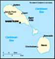
Location: Caribbean, islands in the Caribbean Sea, about one-third of the way from Puerto Rico to Trinidad and Tobago
Geographic coordinates: 17 20 N, 62 45 W
Map references: Central America and the Caribbean
Area: Total: 261 sq km (Saint Kitts 168 sq km; Nevis 93 sq km) land: 261 sq km water: 0 sq km
Area - comparative: 1.5 times the size of Washington, DC
Land boundaries: 0 km
Coastline: 135 km
Maritime claims: Territorial sea: 12 nm contiguous zone: 24 nm exclusive economic zone: 200 nm continental shelf: 200 nm or to the edge of the continental margin
Climate: Tropical tempered by constant sea breezes; little seasonal temperature variation; rainy season (May to November)
Terrain: Volcanic with mountainous interiors
Elevation extremes: Lowest point: Caribbean Sea 0 m highest point: Mount Liamuiga 1,156 m
Natural resources: Arable land
Land use: Arable land: 19.44% permanent crops: 2.78% other: 77.78% (2001)
Irrigated land: NA sq km
Natural hazards: Hurricanes (July to October)
Environment - current issues: NA
Environment - international agreements: Party to: Biodiversity, Climate Change, Desertification, Endangered Species, Hazardous Wastes, Law of the Sea, Ozone Layer Protection, Ship Pollution, Whaling signed, but not ratified: none of the selected agreements
Geography - note: With coastlines in the shape of a baseball bat and ball, the two volcanic islands are separated by a three-km-wide channel called The Narrows; on the southern tip of long, baseball bat-shaped Saint Kitts lies the Great Salt Pond; Nevis Peak sits in the center of its almost circular namesake island and its ball shape complements that of its sister island
Advertisement
The information here has been derived from Public Domain Sources such as the CIA World Factbook. No liability can be taken for any inaccuracies.
Tot: 0.032s; Tpl: 0.009s; cc: 3; qc: 2; dbt: 0.0042s; 1; m:domysql w:travelblog (10.17.0.13); sld: 1;
; mem: 1.1mb
 First settled by the British in 1623, the islands became an associated state with full internal autonomy in 1967. The island of Anguilla rebelled and was allowed to secede in 1971. Saint Kitts and Nevis achieved independence in 1983. In 1998, a vote ...