Advertisement
Published: October 17th 2008
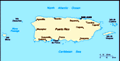
The Spanish Virgin Islands (sometimes known as the Passage Islands) are a group of islands just east of the main island of Puerto Rico. They are part of the Commonwealth of Puerto Rico. Although United States territory, they are politically and culturally distinct from the Territory of the Virgin Islands of the United States (commonly called the U.S. Virgin Islands) which lies to the east of the Spanish Virgin Islands. As part of Puerto Rico, they formerly belonged to Spain, and Spanish remains the predominant language, although English is common.
As Puerto Rican islands, they are often not labeled as part of the Virgin Islands archipelago. However, they are geographically part of the Virgin Islands chain. They are closer to St. Thomas than St. Thomas is to St. Croix, both part of the U.S. Virgin Islands. The term "Spanish Virgin Islands" is common in Puerto Rican tourist literature, but often does not appear on general maps and atlases.
The principal islands of the group are Culebra and Vieques, with multiple associated smaller islands and islets. Many of the smaller islands are part of Culebra National Wildlife Refuge. Much of Vieques is part of Vieques National Wildlife Refuge, formerly a
U.S. Navy facility.
Isla Culebra (IPA: ) (Snake Island) is an island-municipality of Puerto Rico originally called Isla Pasaje and Isla de San Ildefonso. It is located approximately 17 miles east of the Puerto Rican mainland, 12 miles west of St. Thomas and 9 miles north of Vieques.
Culebra is spread over 5 wards and Culebra (Dewey) Pueblo (The downtown area and the administrative center of the city). The island is also known as Isla Chiquita (Little Island) and Ultima Virgen (Last Virgin). Residents of the island are known as Culebrenses.
Christopher Columbus was the first European to discover the island in 1493. The island was populated by Taíno Indians prior to this and would be used by pirates as a refuge for more than 3 centuries.
In 1875, a black Englishman named Stevens was made the first governor of Culebra by the government of Vieques. He was given the task of protecting the island and the fishermen who used the nearby waters from pirates. He was assassinated later that same year. Culebra was then settled by Cayetano Escudero Sanz on October 27, 1880. This first settlement was called San Ildefonso, to honor the Bishop of Toledo, San Ildefonso de la Culebra. Two years later, on September 25, 1882 construction of the Culebrita Lighthouse began and it was completed on February 25, 1886. It was the oldest operating lighthouse in the Caribbean until 1975, when the U.S. Navy and Coast Guard finally closed the facility.
In 1902, Culebra was integrated as a part of Vieques. One year later, on June 26, President Theodore Roosevelt established the Culebra Naval Reservation. A bird refuge was established on February 27, 1909. In 1939, the U.S. Navy began to use the Culebra Archipelago as a gunnery and bombing practice site. This was done in preparation for the United States' involvement in World War II. In 1971 the people of Culebra began protests, known as the Navy-Culebra protests, for the removal of the U.S. Navy from Culebra. Four years later, in 1975, the use of Culebra as a gunnery range ceased and all operations were moved to Vieques.
Culebra was declared an independent island municipality in 1917. The first democratically elected government was put into place in 1960. Prior to this, the government of Puerto Rico appointed delegates to administer the island.
Culebra is an archipelago consisting of the main island and twenty-three smaller islands that lie off its coast. The largest of these cays are: Culebrita to the east, Cayo Norte to the northeast, and Cayo Luis Peña and Cayo Lobo to the west. The smaller islands include Cayo Ballena, Cayos Geniqui, Arrecife Culebrita, Las Hermanas, El Mono, Cayo Lobito, Cayo Botijuela, Alcarraza, Los Gemelos, and Piedra Steven. Islands in the archipelago are arid, meaning they have no rivers or streams. All of the fresh water is brought from Puerto Rico via Vieques.
Culebra is characterized by an irregular topography resulting in a long intricate shoreline. The island is approximately 7 by 5 miles (11 by 8 km). The coast is marked by cliffs, sandy coral beaches and mangrove forests. Inland, the tallest point on the island is Mount Resaca, with an elevation of 650 feet (198 m).
Ensenada Honda is the largest harbor on the island and is considered to be the most hurricane secure harbor in the Caribbean. The capital of the Culebra is Dewey, Puerto Rico.
Vieques (Spanish pronunciation: /'vjɛkɛs/ or /'bjɛkɛs/ or /'βjɛkɛs/; English pronunciation: or ), in full Isla de Vieques, is an island-municipality of Puerto Rico in the northeastern Caribbean. Although Puerto Rico is a U.S. Commonwealth, Vieques, like the rest of Puerto Rico, retains strong Spanish influences from 400 years of Spanish ownership.
Vieques lies about 8 miles (13 km) to the east of the Puerto Rican mainland, and measures approximately 21 miles (34 km) long by 4 miles (6 km) wide. The two main towns of Vieques are Isabel Segunda (sometimes written "Isabel II"), the administrative center located on the northern side of the island, and Esperanza, located on the southern side. At peak, the population of Vieques is around 10,000.
The island's name is a Spanish spelling of a Native American word said to mean "small island". It also has the nickname "Isla Nena", usually translated from the Spanish as "Little Girl Island", as a reference to its being perceived as Puerto Rico's little sister island. During the colonial period the British name was "Crab Island".
Vieques is best known internationally as the site of a series of protests against the US Navy's use of the island as a bombing range and weapons testing ground, which eventually led to the Navy's departure in 2003.
Bioluminescent Bay
The Bioluminescent Bay (or "Bio Bay" as it is sometimes called), is perhaps the world's largest and brightest. The luminescence is caused by micro-organisms (dinoflagellates) which glow whenever the water is disturbed, leaving a trail of neon blue. A combination of factors create the necessary conditions for bioluminescence: red mangrove trees surround the water (the organisms feed off the dead leaves), a complete lack of modern development around the bay, the water is cool enough and deep enough, and a small channel to the ocean keeps the dinoflagellates in the bay. This small channel is the result of Spanish ships's attempts to choke off the bay from the ocean's waters. The Spanish believed that the bioluminescence they first encountered was the work of the Devil ('El Diablo') and tried to block the ocean's waters from entering the bay by dropping huge boulders in the channel. The Spanish only succeeded in preserving and increasing the luminescence. Kayaking and swimming are permitted in the bay and can be arranged through local vendors.
Advertisement
Tot: 0.247s; Tpl: 0.01s; cc: 11; qc: 62; dbt: 0.0992s; 1; m:domysql w:travelblog (10.17.0.13); sld: 1;
; mem: 1.2mb