Jamaican Geography, Jamaica Geography
Advertisement
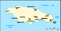
Location: Caribbean, island in the Caribbean Sea, south of Cuba
Geographic coordinates: 18 15 N, 77 30 W
Map references: Central America and the Caribbean
Area: Total: 10,991 sq km land: 10,831 sq km water: 160 sq km
Area - comparative: Slightly smaller than Connecticut
Land boundaries: 0 km
Coastline: 1,022 km
Maritime claims: Measured from claimed archipelagic straight baselines territorial sea: 12 nm contiguous zone: 24 nm exclusive economic zone: 200 nm continental shelf: 200 nm or to edge of the continental margin
Climate: Tropical; hot, humid; temperate interior
Terrain: Mostly mountains, with narrow, discontinuous coastal plain
Elevation extremes: Lowest point: Caribbean Sea 0 m highest point: Blue Mountain Peak 2,256 m
Natural resources: Bauxite, gypsum, limestone
Land use: Arable land: 16.07% permanent crops: 10.16% other: 73.77% (2001)
Irrigated land: 250 sq km (1998 est.)
Natural hazards: Hurricanes (especially July to November)
Environment - current issues: Heavy rates of deforestation; coastal waters polluted by industrial waste, sewage, and oil spills; damage to coral reefs; air pollution in Kingston results from vehicle emissions
Environment - international agreements: Party to: Biodiversity, Climate Change, Climate Change-Kyoto Protocol, Desertification, Endangered Species, Hazardous Wastes, Law of the Sea, Marine Dumping, Marine Life Conservation, Ozone Layer Protection, Ship Pollution, Wetlands signed, but not ratified: none of the selected agreements
Geography - note: Strategic location between Cayman Trench and Jamaica Channel, the main sea lanes for the Panama Canal
Advertisement
The information here has been derived from Public Domain Sources such as the CIA World Factbook. No liability can be taken for any inaccuracies.
Tot: 0.043s; Tpl: 0.007s; cc: 3; qc: 2; dbt: 0.0049s; 1; m:domysql w:travelblog (10.17.0.13); sld: 1;
; mem: 1.1mb
 Jamaica gained full independence within the British Commonwealth in 1962. Deteriorating economic conditions during the 1970s led to recurrent violence and a drop off in tourism. Elections in 1980 saw the democratic socialists voted out of office. Pol...