Caymanian Geography, Cayman Islands Geography
Advertisement
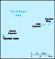
Location: Caribbean, island group in Caribbean Sea, nearly one-half of the way from Cuba to Honduras
Geographic coordinates: 19 30 N, 80 30 W
Map references: Central America and the Caribbean
Area: Total: 262 sq km land: 262 sq km water: 0 sq km
Area - comparative: 1.5 times the size of Washington, DC
Land boundaries: 0 km
Coastline: 160 km
Maritime claims: Territorial sea: 12 nm exclusive fishing zone: 200 nm
Climate: Tropical marine; warm, rainy summers (May to October) and cool, relatively dry winters (November to April)
Terrain: Low-lying limestone base surrounded by coral reefs
Elevation extremes: Lowest point: Caribbean Sea 0 m highest point: The Bluff 43 m
Natural resources: Fish, climate and beaches that foster tourism
Land use: Arable land: 3.85% permanent crops: 0% other: 96.15% (2001)
Irrigated land: NA sq km
Natural hazards: Hurricanes (July to November)
Environment - current issues: No natural fresh water resources; drinking water supplies must be met by rainwater catchments
Environment - international agreements:
Geography - note: Important location between Cuba and Central America
Advertisement
The information here has been derived from Public Domain Sources such as the CIA World Factbook. No liability can be taken for any inaccuracies.
Tot: 0.036s; Tpl: 0.008s; cc: 5; qc: 8; dbt: 0.0081s; 1; m:domysql w:travelblog (10.17.0.13); sld: 1;
; mem: 1.1mb
 The Cayman Islands were colonized from Jamaica by the British during the 18th and 19th centuries. Administered by Jamaica since 1863, they remained a British dependency after 1962 when the former became independent....