Advertisement
Published: December 23rd 2014
Sunday 21st December, 2014. Anguilla & Saint Martin or Sint Maarten, Leeward Islands, Lesser Antilles, West Indies
This little island of two nations (Dutch Sint Maarten and French Saint Martin) is situated between the islands of Anguilla and St Barths. It covers and area of about 34 square miles shared between the two countries. The smaller land mass on the southern side has been a constituent country of the Kingdom of the Netherlands since the Dutch Antilles dissolved in October 2010. The northern side of the island, which covers a greater area constitutes the French overseas collectivity.
Dutch St Maarten is known for its sheltered beaches and modern shopping while the French side is known for its beaches and "haute cuisine". Many centuries ago the Leeward Islands were inhabited by the Siboney and Arawak Indians who called this island 'Soualiga' meaning 'land of salt'. They wre followed by the fierce cannibalistic Caribs. The island was given its current name by CC who first sighted these shores on 11 November 1793 - the feast day of St Martin of tours. It was then squabbled over by the Spanish and Dutch until the Spanish no longer needed a Caribbean base and
simply left. The Dutch went to claim the island but found that the French had also arrived. In March 1648 the French and Dutch signed the Treaty of Concordia which was a written agreement to share the island. This treaty is thought to be the oldest between any two nations and is still valid to this day.
No-one knows exactly how the island was split but legend has it that a Frenchman and a Dutchman divided the island by standing back to back and walking in oposite directions from a certain point on the coast. They promised to establish a boundary from the point where they had started to that at which they would meet. The Frenchman was fitter and managed to cover more land than the Dutchman who is also said to have lost valuable time by making stops for a crafty swig of Old Dutch Gin. Tipsy he might have been, but he was cunning enough to walk towards the more prosperous end of the island which contained the Salt Ponds, along with the best land and the harbour. At first the French/Dutch relationship wasn't too good. The Dutch side became an important trade centre for cotton,
salt, tobacco and sugar. hundreds of slaves were brought in to work on the plantations. France abolished slavery in 1848 and the Dutch followed suit 15 years later which resulted in an economic depression which lasted until 1939.
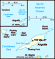
We docked in St Philipsburg which is the Capital of Dutch St Maarten and the largest town on the island. It sits on a narrow strip of land that separates the Salt Pond in the North from Great Bay in the South. The Cruise Ship complex is about 1 mile from Philipsburg town. We had a posh breakfast and alighted the ship and made straight for the information office. We rather fancied a trip to Anguilla which would add another island to our tally. We found out that we needed our passports as we would be going to another country. D went back to retrieve them while M went and found some cold remedy capsules.
Armed with a map and our passports we walked into St Philipsburg and caught the local bust to Marigot which is the Capital of the French side of the island. We found the local ferry dock and after paying our departure tax (3$ US), and
clearing customs we boarded the ferry. The ferry company was called the Niki-V. If you were staying longer than a day you had to fill in a landing card. Dwain who was the conductor on the Niki-V ferry came along and collected our money and gave us a map of Anguilla. On arrival we had to go through passport control - where we had our passports stamped. Then we went through the 'nothing to declare' channel of customs. Once outside we decided to hire a taxi for an island tour as it turns out that D would have to buy a temporary driving licence if we wanted to hire a car.
We had a 12 seater mini bus all to ourselves - don't think the drive was too happy about this. First he took us to the CuisinArt Hotel which is one of the flash resorts on the Island. Turns out that this is pretty much all there is on Anguilla - very high end tourism. Most of the guests are from the USA and South America.
Next he drove us to the Cap Juluca Resort. This is a flash hotel located at Maundays Bay. Outside the main
lobby there was a place for parking your Solar powered Cart. We walked around the side of the building (it was still being repaired following a recent hurricane). Here we came to Maundays Bay Beach which was absolutely beautiful with powdery white sand and clear blue water. We could see the hotel accommodation around the end of the bay. There were two guests taking in some rays on the beach. As in the UK all the beaches on Anguilla are public beaches so anyone can come but they have to bring your own parasols and beach pariphinalia.
We drove past the Etangs at Malliouhana Resort where you can sometimes see Iguanas. These are not indigenous to Anguilla but arrived during a hurricane in 1995. We turned off the road and travelled on a road called Back Street. We stopped at a viewpoint which looked out over Sandy Ground and Road Bay. There were plenty of flash yachts bobbing around in the clear blue sea and if you looked really carefully you could see Green Turtles coming up for a breath of air amongst the boats. Behind the resort of Sandy Ground is a large etang from which salt used
to be collected.
We drove past the oldest guest house in Anguilla, which is in Old Valley (the former capital). It is now Lloyds B & B. Formerly all visting VIP's would have stayed here. Now they use the flash modern resorts. Next was Ebenezer Methodist Church which is the oldest church on the Island. Our driver then took us to The Valley which is the Capital of Anguilla tosee the Police HQ, Government Buildings and HM Prison before returning us to the ferry port via an ATM. We had a beer and purchased a FM before purchasing our tickets, paying our departure tax (which was $16 US from this side!) and clearing security.
We arrived back at Marigot Port. From the 17th century some French families settled in the northen part of the great pond of Simpson Bay. They named this place Marigot because of the swamp and mangroves that bordered the pond.
There, they were cultivating tobacco, some cotton and indigo, but their crops were
usually destroyed by incursions of British privateers and pirates. It was only the arrival of the knight Descoudrelles, commander of the islands of Saint Martin and Saint Barthelomy in 1764
that led to the development and prosperity of this little town during the 18th century. As soon as he arrived Descoudrelles wrote that the biggest impediment for a solid establishment in Saint Martin is the cruel way the British always treated the inhabitants of this island that has always been taken by force by privateers or individuals who evicted the inhabitants every time having plundered and burned everything that they possessed. It was all our fault and the locals felt that they needed to defend themselves. A marine map dating from 1765 shows the intention to install 3 batteries of cannon to protect the bay of Marigot. One at Point Bluff, one on Round Hill and the third one on Marigot Hill.
The installation on Marigot Hill is called Fort Louis. We had seen it sitting on a hill dominating the town from the ferry. We walked up some steep steps and up a steep hill to the entrance to the fort. The fort's entrance doors were removed in 1820. The ruined pilasters and uprights still remain though. We strolled around taking some pictures of the canon and magnificent views and reading all the blurb about the fort.
Next we strolled around the old marina with its lovely shops and flash boats. We caught the bus back to Philipsburg. We walked the mile back to the cruise terminal and just made it in time for tea. Dinner was nondescript as was the company.
.
Advertisement
Tot: 0.085s; Tpl: 0.013s; cc: 6; qc: 32; dbt: 0.0527s; 1; m:domysql w:travelblog (10.17.0.13); sld: 1;
; mem: 1.1mb