Advertisement
Published: October 7th 2009

 On the Cà Mau cape
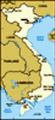
The words mean "The national trig point GPS 0001"26 September 2009 - After traveling for 2 hours by plane from Hanoi to Cần Thơ, 4 hours by bus from Cần Thơ - Sóc Trăng - Bạc Liêu - Cà Mau and then 2 hours by water taxi, I reached the Cà Mau cape (Mũi Cà Mau), which is the southernmost point of Vietnam. This is one of my dreams that came true. As some of you have not been to Vietnam, let me explain a little bit about Vietnam. The country looks like an "S" shape. It borders with China in the north, Laos and Cambodia in the west and has a long coastline (3260km). The northernmost point of Vietnam is the Nho Quế river which runs between steep mountains. The other side of the river is China and on our side, there is Xéo Lủng village where about 100 H'mong ethnic people are living. Only soldiers in charge of border guarding make patrol in this area and it often takes them one or two days to go along the border line. We travelers are not allowed to reach this sensitive area. The national trig point that we can visit is placed at Lũng Cú near this area (see
The southernmost point of Vietnam
The boat in this photo is placed at the southernmost point of Vietnam. The red words on the boat "Cà Mau cape 8°.37'.30'' Northern latitude and 104°.43' Eastern longitude". The boat looks small in this photo but it's very big in reality (Mũi Cà Mau, 8°.37'.30'' Vĩ độ bắc và 104°.43' Kinh độ đông). the link below).
The southernmost point of Vietnam is the Cà Mau cape. Every year the cape naturally extends about 80-100m into the sea through deposits of sand. Our guide joked that the northernmost point of Vietnam looked like a conical hat, while the southernmost point looked like a big toe.
We left Cà Mau city at 8am and it took us 2 hours to travel from the city to the southern tip (100km river way). Our 25 seater water taxi was going along the Bảy Háp river towards the southern tip and on the way we passed by local houses, Cà Mau floating market and Năm Căn district. The National Highway No. 1 starts from Km 0 in Lạng Sơn province (Friendship Pass, Vietnam - China border crossing) and runs along the whole country like a backbone and ends at Km 2300 in Năm Căn district (50km away from Cà Mau city). As I traveled by water taxi from Cà Mau, I missed the chance to take a photo of Km 2300 (I had a photo of Km 0 in my Nanning Blog). Km 2300 is the end of the road in Vietnam and from there to
Our water taxi from Cà Mau to the southern tip
We traveled by this 25-seated water taxi for two hours from the city to the southern tip and then back in the city in the afternoon. the southern tip, water taxi is the only means of transport in this area. We also saw the final ferry of Vietnam. There are many ferries along Vietnam, but the ferry in Năm Căn is the southernmost one.
During the first hour of the trip, the weather was great. Whenever there was a water taxi coming from the opposite direction, the waves from it made our water taxi rise up and down like a car going over speed ramps. It was even worse when our water taxi went out to the open sea. The bad weather (rain and wind) made the waves higher. Our water taxi was struggling to go over the waves and the sea water got into our water taxi, even though the windows and the door were closed. I sat in the front of the boat, so my trousers and backpack were wet. Some old people on the tour were panicked and they said they would not want to go further, while two people started wearing life jackets. The driver reassured us that everything would be alright, while he controlled the windscreen wiper with his hand (not automatically like cars) as the rain made all screens
On the way to the southern tip
Our water taxi is going along Bảy Háp river from Cà Mau city to the southern tip. A big ship is coming from the opposite direction. unclear. After we turned left and continued our way along the river, things were back to normal and we saw villages and mangrove trees along the banks. We passed by the Cà Mau cape national park before the water taxi stopped at the wharf and we stepped onto the Cà Mau cape (the southernmost point of Vietnam) in Ngọc Hiển district, Cà Mau province.
There are 3 must sees on the cape. A local girl, who was the guide on the cape, took us to the sites. The first place is the star which is the national trig point GPS 0001. The second place is the boat right on the cape with Vietnam's flag and on the boat there are the red words "Cà Mau cape 8°.37'.30'' Northern latitude and 104°.43' Eastern longitude". We saw many piles driven near the place and they are used for embankment work. I asked our guide and he said that in the future when the cape further extends into the sea (80-100m per year), the piles will also be moved. After having lunch, we climbed up the observation tower and enjoyed the great view of the cape and mangrove forests. At 12:30pm, we
had to go back to the boat as the tide was receding. The water taxi driver was afraid that it would be slow to get out of the area. So our total time on the cape was only 2 and a half hours, including lunch.
It took us another 2 hours to go back to Cà Mau city, but this time everything was smooth as our water taxi didn't go against the wind like in the morning. While waiting for our bus to come, I took photos of a snail and oyster shop on the pavement by the Cà Mau bridge, a python and snake shop, and next to it are rat cages for sale as the food for pythons and snakes. Snake meat is a popular food in the Mekong Delta and you also can find crocodile meat. Our guide said the locals also eat rats but I didn't see the food.
This is my last blog about the 5 day trip to the southernmost region of Vietnam. It was also my 4th visit to the Mekong Delta. There are 13 provinces in this region and I've been to 10 of them. September was an interesting month
The national trig point
This is the place where I took a photo of the national trig point GPS 0001 (photo No. 1). for me. At the beginning of the month, I was walking on the Vietnam - China border crossing and going up the mountains to see Bắc Hà Sunday market of the H'mong people. At the end of the month, I was on the other side of the country and even reached the southernmost point of Vietnam. Hopefully I will go to the Central Highlands of Vietnam (off the beaten path) in early December and visit the coffee plantations in this region.
Travel tips: When you go on Sinh cafe tours, they will take you to as far as Cần Thơ city (the biggest city in the Mekong Delta). You can go by local bus from Cần Thơ to Sóc Trăng and Bạc Liêu then Cà Mau. This route is off the beaten path and you will rarely see any foreign tourists. The distance from Cần Thơ to Cà Mau is 180km. If you go further to Năm Căn (end of Vietnam's road), it will be 230km from Cần Thơ. I heard that there is only one good hotel in Năm Căn, so it's better to stay in Cà Mau city. The bus is OK on the whole route. The
View of the Cà Mau cape
This is view of the Cà Mau cape (the southernmost point of Vietnam) from the observation tower. It looks similar to the cape in the Vietnam's map. The building is the restaurant where we had lunch. problem is the local water taxis. I mean the safety when traveling by this type of boat. My Vietnamese friend used to travel by this boat and it was a scary experience as he said. Some local water taxis are not equipped with life jackets and they often stop on the way for picking up more guests. You can go by water taxi to the southern tip from either Cà Mau or Năm Căn.
Other blogs about the same trip:
Cần Thơ (Mekong Delta - part 1) Sóc Trăng (Mekong Delta - part 2) Bạc Liêu (Mekong Delta - part 3) Blog about the northernmost point of Vietnam:
Hà Giang - Part 3 (Đồng Văn & Lũng Cú) Note: As tourists, we are only permitted to visit Lũng Cú flag tower and cannot go farther as this is the frontier area between Vietnam and China.
Mũi Cà Mau - Ngày 26/9/2009 Sau 2 tiếng đồng hồ bay từ Hà Nội đến Cần Thơ, 4 tiếng đồng hồ đi bằng xe buýt từ Cần Thơ - Sóc Trăng - Bạc Liêu - Cà Mau, cộng thêm 2 tiếng đồng hồ đi bằng cano cao tốc, cuối cùng tôi cũng đã đặt chân lên vùng đất Mũi Cà Mau, điểm cực nam của Tổ Quốc. Vậy là một trong những
ước mơ của tôi đã trở thành hiện thực.
8 giờ sáng, đoàn chúng tôi lên tàu cano cao tốc hướng về đất mũi và thời gian dự kiến là mất 2 tiếng đồng hồ để đi từ thành phố Cà Mau đến Mũi Cà Mau (100km đường sông). Chúng tôi đi dọc theo sông Bảy Háp và nhìn thấy những căn nhà dọc bờ sông, chợ nổi Cà Mau, những chiếc phao nổi dọc đường, tàu bè qua lại mà đặc biệt là loại thuyền nhỏ làm bằng nhựa composit mà người dân ở đây sơn viền màu xanh ở hai bên thân tàu và gọi theo tiếng địa phương là "vỏ lãi". Một tiếng đồng hồ đầu tiên, trời nắng đẹp. Mỗi khi có chiếc tàu nào đi ngược chiều và tạo thành những con sóng thì cano của chúng tôi lại bị xóc và nghe rõ tiếng lộc cộc như xe ô tô đang đi trên ổ gà. Chúng tôi đi qua Năm Căn là một huyện của tỉnh Cà Mau nơi Quốc lộ 1 kết thúc ở đây. Đường Quốc lộ số 1 bắt đầu từ Km 0 tại Hữu Nghị Quan là cửa khẩu
Our water taxi from Cà Mau to the southern tip
Some women on the tour are getting inside the water taxi. I am the last person who come into the boat so I sit on the front side, right behind the driver. Việt Nam - Trung Quốc ở tỉnh Lạng Sơn, chạy dọc theo suốt chiều dài Việt Nam và kết thúc ở Km 2300 tại Năm Căn. Từ Năm Căn nếu muốn đến Mũi Cà Mau thì phải đi bằng cano cao tốc. Đoàn chúng tôi đi từ thành phố Cà Mau nên tôi không có cơ hội chụp cột mốc Km 2300. Trước đây tôi đã chụp ảnh cột mốc Km 0 trong chuyến đi Nam Ninh hồi tháng 4 năm ngoái.
Trời bắt đầu âm u với mây đen ở phía trước và sắp mưa to. Khi cano của chúng tôi đi dọc theo đoạn sông với cây đước trồng ở hai bên bờ thì trời bắt đầu mưa và chúng tôi phải đóng tất cả các cửa sổ và cả cửa ra vào. Tôi ngồi ngay ở hàng đầu và nhìn thấy người lái tàu dùng tay điều khiển cần gạt nước ở kính trước của chiếc cano. Cần gạt nước này không tự động như là xe ô tô. Xung quanh chúng tôi mưa trắng xoá và chẳng nhìn thấy gì hết cả. Bản thân chiếc kính chắn gió của người lái tàu cũng bị mờ
Cầu khỉ (monkey bridge)
This monkey bridge over canal used to be popular in the Mekong Delta. Now most of the monkey bridges have been replaced with concrete ones. This shot was taken when we were walking to the trig point on the Cà Mau cape. đi, nhưng anh vẫn bình tình giữ tốc độ chạy nhanh. Hết đoạn sông, tàu của chúng tôi ra đến biển. Lúc này sóng rất to vì gió lớn. Chiếc cano chồm lên những con sóng và xóc đến mức chúng tôi bị hất lên, đầu chạm trần và nước biển tràn vào tàu, mặc dù tất cả các cửa đều đóng chặt. Tôi ngồi ở phía trên nên bị ướt quần và ba lô. Mây cô trong đoàn hốt hoảng và nói rằng họ không muốn đi nữa. Anh lái tàu phải động viên là mọi việc sẽ ổn thoả thôi. Ông cụ 77 tuổi và một chị thì lôi áo phao để ở trên trần ra mặc. Cuối cùng thì tàu của chúng tôi cũng rẽ trái và lại đi vào một dòng sông khác, qua một thị trấn nhỏ và thấy rõ nhà dân ở hai bên bờ, qua rừng quốc gia Mũi Cà Mau và dừng lại ở một bến tàu nhỏ. Đây chính là đất Mũi Cà Mau thuộc huyện Ngọc Hiển là huyện cuối cùng của tỉnh Cà Mau và Việt Nam.
Chúng tôi theo chân cô gái hướng dẫn viên người địa
View along Bảy Háp river
Our boat is on the way to the southern tip. phương đi thăm cột mốc toạ độ quốc gia. Cô gái mang theo chiếc loa và giọng nói của cô vang lên làm cho bầu không khí yên tĩnh ở đây nhộn nhịp hơn. Ngoài đoàn của chúng tôi có 23 người (kể cả anh hướng dẫn viên người Vĩnh Long), lúc đó còn có thêm một đoàn khách khác nữa nên cũng vui. Chúng tôi đi qua một con đường nhỏ với hàng cây ở hai bên đường và cô gái hướng dẫn viên chỉ cho chúng tôi xem cây mắm và quả của nó. Như vậy là có 3 loại cây mọc chủ yếu ở vùng này là cây đước (có rễ lộ thiên ở gốc cây), cây tràm và cây mắm. Chúng tôi đi ra mốc toạ độ quốc gia GPS 0001 có hình ngôi sao 6 cánh mà 2 cánh trong số đó có dòng chữ mốc toạ độ. Tiếp theo, chúng tôi đi ra điểm cực nam là nơi có một chiếc thuyền lớn với lá cờ đỏ sao vàng tung bay. Trên thuyền có dòng chữ màu đỏ "Mũi Cà Mau, 8°.37'.30'' Vĩ độ bắc và 104°.43' Kinh độ đông". Đây cũng chính là
điểm cuối cùng của đất liền Việt Nam. Hàng năm, Mũi Cà Mau lấn biển từ 80-100m và tôi nhìn thấy một hàng cọc ở gần đó. Người ta đang chuẩn bị kè để khỏi bị sạt lở đất. Anh hướng dẫn viên nói với tôi là khi đất liền lấn ra biển thì sau này cọc đó cũng sẽ được di chuyển theo. Anh cũng nói là vùng đất mới này được đặt tên là Xóm Đất Mới.
Sau khi chụp ảnh xong, chúng tôi vào nhà hàng Mũi Cà Mau ở gần đó và ăn trưa. Món "ốc len xào dừa" ở đây rất đặc biệt và chúng tôi phải hút con ốc từ phần đuôi của nó. Sau khi ăn trưa xong, chúng tôi được 20 phút leo lên đài quan sát. Tôi cũng cảm thấy hơi chóng mặt sau khi leo lên cao và nhìn xuống dưới sâu hun hút. Từ trên nóc của đài quan sát có thể nhìn thấy toàn cảnh đất mũi giống như trên bản đồ, chiếc thuyền toạ độ và nhà hàng ở gần đó, những cánh rừng bạt ngàn cây xanh và một chiếc thuyền chở rau quả đang
đi giữa dòng sông ra biển. 12 giờ rưỡi chiều, chúng tôi quay lại tàu cano để quay về Cà Mau. Anh lái tàu lo ngại là thuỷ triều đang xuống thì tàu đi sẽ bị chậm. Vì đi xuôi chiều nên tàu của chúng tôi đi xuôn xẻ hơn so với buổi sáng. Đôi lúc tàu cano nghiêng và chúng tôi có cảm giác như nước sông ở ngay sát cạnh cửa sổ. Như vậy là cả chiều đi và về, tàu của chúng tôi đều mất hơn 2 tiếng đồng hồ, tức là khoảng 2 tiếng 20 phút, mặc dù tàu chạy rất nhanh.
Để đi đến Mũi Cà Mau, bạn có thể đi bằng đường bộ từ Sài Gòn hoặc Cần Thơ đến Cà Mau hoặc Năm Căn rồi đi tàu cano cao tốc ra đất mũi. Khoảng cách từ Cần Thơ đến Cà Mau là 180km, đi mất 4 tiếng đồng hồ. Một người bạn của tôi đã đi đến tận Năm Căn và nói rằng khách sạn ở đó không nhiều lắm, chỉ có Khách sạn Công Đoàn là trọ được, vì vậy nên có nhiều lựa chọn hơn nếu ở Cà Mau. Bạn
A cafeteria in Cà Mau city
This cafeteria is located next to our hotel. có thể đi bằng cano cao tốc từ Cà Mau hoặc Năm Căn (Cà Mau cách Năm Căn 50km đường bộ), tuy nhiên như bạn của tôi kể thì cano này không có áo phao và dừng nhiều lần dọc đường để đón khách. Vì tôi đi theo tour nên cano có lẽ cũng tốt hơn và có áo phao. Có 3 nơi thăm quan ở đất mũi như tôi đã nêu ở trên là mốc toạ độ quốc gia, chiếc thuyền ở điểm cực nam của Tổ Quốc và đài quan sát.
Đây là lần thứ tư tôi đến Đồng bằng sông Cửu Long và tôi đã đến thăm 10 trong số 13 tỉnh ở khu vực này. Chỉ còn 3 tỉnh mà tôi chưa đến thăm là tỉnh Kiên Giang, Trà Vinh và Long An. Nơi tiếp theo ở Việt Nam mà tôi muốn đến thăm là Tây Nguyên. Hy vọng tôi sẽ có chuyến đi đến vùng đất mới này vào mùa khô năm nay.
Blog về chuyến đi đến cột cờ Lũng Cú (điểm cực bắc của Việt Nam) tại Hà Giang vào năm 2012:
Hà Giang - Part 3 (Đồng Văn & Lũng Cú)
Advertisement
Tot: 0.104s; Tpl: 0.021s; cc: 16; qc: 29; dbt: 0.0433s; 1; m:domysql w:travelblog (10.17.0.13); sld: 1;
; mem: 1.2mb


Hideyuki Kobayashi
non-member comment
Mũi Cà Mau
Dear Ms Ha, It seems you enjoyed adventurous trips in September 2009. I admire how you are a superwoman. Anyway, thanks for your good depiction on Vietnam, Best Wishes from Kob.