Thai Geography, Thailand Geography
Advertisement
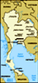
Location: Southeastern Asia, bordering the Andaman Sea and the Gulf of Thailand, southeast of Burma
Geographic coordinates: 15 00 N, 100 00 E
Map references: Southeast Asia
Area: Total: 514,000 sq km land: 511,770 sq km water: 2,230 sq km
Area - comparative: Slightly more than twice the size of Wyoming
Land boundaries: Total: 4,863 km border countries: Burma 1,800 km, Cambodia 803 km, Laos 1,754 km, Malaysia 506 km
Coastline: 3,219 km
Maritime claims: Territorial sea: 12 nm exclusive economic zone: 200 nm continental shelf: 200-m depth or to the depth of exploitation
Climate: Tropical; rainy, warm, cloudy southwest monsoon (mid-May to September); dry, cool northeast monsoon (November to mid-March); southern isthmus always hot and humid
Terrain: Central plain; Khorat Plateau in the east; mountains elsewhere
Elevation extremes: Lowest point: Gulf of Thailand 0 m highest point: Doi Inthanon 2,576 m
Natural resources: Tin, rubber, natural gas, tungsten, tantalum, timber, lead, fish, gypsum, lignite, fluorite, arable land
Land use: Arable land: 29.36% permanent crops: 6.46% other: 64.18% (2001)
Irrigated land: 47,490 sq km (1998 est.)
Natural hazards: Land subsidence in Bangkok area resulting from the depletion of the water table; droughts
Environment - current issues: Air pollution from vehicle emissions; water pollution from organic and factory wastes; deforestation; soil erosion; wildlife populations threatened by illegal hunting
Environment - international agreements: Party to: Biodiversity, Climate Change, Climate Change-Kyoto Protocol, Desertification, Endangered Species, Hazardous Wastes, Marine Life Conservation, Ozone Layer Protection, Tropical Timber 83, Tropical Timber 94, Wetlands signed, but not ratified: Law of the Sea
Geography - note: Controls only land route from Asia to Malaysia and Singapore
Advertisement
The information here has been derived from Public Domain Sources such as the CIA World Factbook. No liability can be taken for any inaccuracies.
Tot: 0.021s; Tpl: 0.007s; cc: 3; qc: 2; dbt: 0.0032s; 1; m:domysql w:travelblog (10.17.0.13); sld: 1;
; mem: 1.1mb
 A unified Thai kingdom was established in the mid-14th century. Known as Siam until 1939, Thailand is the only Southeast Asian country never to have been taken over by a European power. A bloodless revolution in 1932 led to a constitutional monarchy....