Mongolian Geography, Mongolia Geography
Advertisement
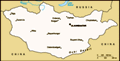
Location: Northern Asia, between China and Russia
Geographic coordinates: 46 00 N, 105 00 E
Map references: Asia
Area: Total: 1,564,116 sq km
Area - comparative: Slightly smaller than Alaska
Land boundaries: Total: 8,220 km border countries: China 4,677 km, Russia 3,543 km
Coastline: 0 km (landlocked)
Maritime claims: None (landlocked)
Climate: Desert; continental (large daily and seasonal temperature ranges)
Terrain: Vast semidesert and desert plains, grassy steppe, mountains in west and southwest; Gobi Desert in south-central
Elevation extremes: Lowest point: Hoh Nuur 518 m highest point: Nayramadlin Orgil (Huyten Orgil) 4,374 m
Natural resources: Oil, coal, copper, molybdenum, tungsten, phosphates, tin, nickel, zinc, fluorspar, gold, silver, iron
Land use: Arable land: 0.77% permanent crops: 0% other: 99.23% (2001)
Irrigated land: 840 sq km (1998 est.)
Natural hazards: Dust storms, grassland and forest fires, drought, and "zud," which is harsh winter conditions
Environment - current issues: Limited natural fresh water resources in some areas; the policies of former Communist regimes promoted rapid urbanization and industrial growth that had negative effects on the environment; the burning of soft coal in power plants and the lack of enforcement of environmental laws severely polluted the air in Ulaanbaatar; deforestation, overgrazing, and the converting of virgin land to agricultural production increased soil erosion from wind and rain; desertification and mining activities had a deleterious effect on the environment
Environment - international agreements: Party to: Biodiversity, Climate Change, Climate Change-Kyoto Protocol, Desertification, Endangered Species, Environmental Modification, Hazardous Wastes, Law of the Sea, Ozone Layer Protection, Wetlands signed, but not ratified: none of the selected agreements
Geography - note: Landlocked; strategic location between China and Russia
Advertisement
The information here has been derived from Public Domain Sources such as the CIA World Factbook. No liability can be taken for any inaccuracies.
Tot: 0.049s; Tpl: 0.007s; cc: 5; qc: 6; dbt: 0.0056s; 1; m:domysql w:travelblog (10.17.0.13); sld: 1;
; mem: 1.1mb
 The Mongols gained fame in the 13th century when under Chinggis KHAN they conquered a huge Eurasian empire. After his death the empire was divided into several powerful Mongol states, but these broke apart in the 14th century. The Mongols eventually ...