Zimbabwean Geography, Zimbabwe Geography
Advertisement
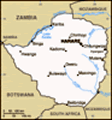
Location: Southern Africa, between South Africa and Zambia
Geographic coordinates: 20 00 S, 30 00 E
Map references: Africa
Area: Total: 390,580 sq km land: 386,670 sq km water: 3,910 sq km
Area - comparative: Slightly larger than Montana
Land boundaries: Total: 3,066 km border countries: Botswana 813 km, Mozambique 1,231 km, South Africa 225 km, Zambia 797 km
Coastline: 0 km (landlocked)
Maritime claims: None (landlocked)
Climate: Tropical; moderated by altitude; rainy season (November to March)
Terrain: Mostly high plateau with higher central plateau (high veld); mountains in east
Elevation extremes: Lowest point: junction of the Runde and Save rivers 162 m highest point: Inyangani 2,592 m
Natural resources: Coal, chromium ore, asbestos, gold, nickel, copper, iron ore, vanadium, lithium, tin, platinum group metals
Land use: Arable land: 8.32% permanent crops: 0.34% other: 91.34% (2001)
Irrigated land: 1,170 sq km (1998 est.)
Natural hazards: Recurring droughts; floods and severe storms are rare
Environment - current issues: Deforestation; soil erosion; land degradation; air and water pollution; the black rhinoceros herd - once the largest concentration of the species in the world - has been significantly reduced by poaching; poor mining practices have led to toxic waste and heavy metal pollution
Environment - international agreements: Party to: Biodiversity, Climate Change, Desertification, Endangered Species, Law of the Sea, Ozone Layer Protection signed, but not ratified: none of the selected agreements
Geography - note: Landlocked; the Zambezi forms a natural riverine boundary with Zambia; in full flood (February-April) the massive Victoria Falls on the river forms the world's largest curtain of falling water
Advertisement
The information here has been derived from Public Domain Sources such as the CIA World Factbook. No liability can be taken for any inaccuracies.
Tot: 0.046s; Tpl: 0.012s; cc: 6; qc: 6; dbt: 0.0106s; 1; m:domysql w:travelblog (10.17.0.13); sld: 1;
; mem: 1.1mb
 The UK annexed Southern Rhodesia from the South Africa Company in 1923. A 1961 constitution was formulated that favored whites in power. In 1965 the government unilaterally declared its independence, but the UK did not recognize the act and demanded ...