Reunionese Geography, Reunion Geography
Advertisement
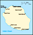
Location: Southern Africa, island in the Indian Ocean, east of Madagascar
Geographic coordinates: 21 06 S, 55 36 E
Map references: World
Area: Total: 2,517 sq km land: 2,507 sq km water: 10 sq km
Area - comparative: Slightly smaller than Rhode Island
Land boundaries: 0 km
Coastline: 207 km
Maritime claims: Territorial sea: 12 nm exclusive economic zone: 200 nm
Climate: Tropical, but temperature moderates with elevation; cool and dry from May to November, hot and rainy from November to April
Terrain: Mostly rugged and mountainous; fertile lowlands along coast
Elevation extremes: Lowest point: Indian Ocean 0 m highest point: Piton des Neiges 3,069 m
Natural resources: Fish, arable land, hydropower
Land use: Arable land: 13.6% permanent crops: 1.2% other: 85.2% (2001)
Irrigated land: 120 sq km (1998 est.)
Natural hazards: Periodic, devastating cyclones (December to April); Piton de la Fournaise on the southeastern coast is an active volcano
Environment - current issues: NA
Environment - international agreements:
Geography - note: This mountainous, volcanic island has an active volcano, Piton de la Fournaise; there is a tropical cyclone center at Saint-Denis, which is the monitoring station for the whole of the Indian Ocean
Advertisement
The information here has been derived from Public Domain Sources such as the CIA World Factbook. No liability can be taken for any inaccuracies.
Tot: 0.034s; Tpl: 0.007s; cc: 3; qc: 10; dbt: 0.0095s; 1; m:domysql w:travelblog (10.17.0.13); sld: 1;
; mem: 1.1mb
 The Portuguese discovered the uninhabited island in 1513. From the 17th to the 19th centuries, French immigration, supplemented by influxes of Africans, Chinese, Malays, and Malabar Indians, gave the island its ethnic mix. The opening of the Suez Can...