Mauritanian Geography, Mauritania Geography
Advertisement
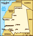
Location: Northern Africa, bordering the North Atlantic Ocean, between Senegal and Western Sahara
Geographic coordinates: 20 00 N, 12 00 W
Map references: Africa
Area: Total: 1,030,700 sq km land: 1,030,400 sq km water: 300 sq km
Area - comparative: Slightly larger than three times the size of New Mexico
Land boundaries: Total: 5,074 km border countries: Algeria 463 km, Mali 2,237 km, Senegal 813 km, Western Sahara 1,561 km
Coastline: 754 km
Maritime claims: Territorial sea: 12 nm contiguous zone: 24 nm exclusive economic zone: 200 nm continental shelf: 200 nm or to the edge of the continental margin
Climate: Desert; constantly hot, dry, dusty
Terrain: Mostly barren, flat plains of the Sahara; some central hills
Elevation extremes: Lowest point: Sebkhet Te-n-Dghamcha -5 m highest point: Kediet Ijill 915 m
Natural resources: Iron ore, gypsum, copper, phosphate, diamonds, gold, oil, fish
Land use: Arable land: 0.48% permanent crops: 0.01% other: 99.51% (2001)
Irrigated land: 490 sq km (1998 est.)
Natural hazards: Hot, dry, dust/sand-laden sirocco wind blows primarily in March and April; periodic droughts
Environment - current issues: Overgrazing, deforestation, and soil erosion aggravated by drought are contributing to desertification; very limited natural fresh water resources away from the Senegal, which is the only perennial river; locust infestation
Environment - international agreements: Party to: Biodiversity, Climate Change, Desertification, Endangered Species, Hazardous Wastes, Law of the Sea, Ozone Layer Protection, Ship Pollution, Wetlands signed, but not ratified: none of the selected agreements
Geography - note: Most of the population concentrated in the cities of Nouakchott and Nouadhibou and along the Senegal River in the southern part of the country
Advertisement
The information here has been derived from Public Domain Sources such as the CIA World Factbook. No liability can be taken for any inaccuracies.
Tot: 0.032s; Tpl: 0.007s; cc: 6; qc: 6; dbt: 0.0078s; 1; m:domysql w:travelblog (10.17.0.13); sld: 1;
; mem: 1.1mb
 Independent from France in 1960, Mauritania annexed the southern third of the former Spanish Sahara (now Western Sahara) in 1976, but relinquished it after three years of raids by the Polisario guerrilla front seeking independence for the territory. ...