Guinean Geography, Guinea Geography
Advertisement
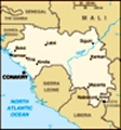
Location: Western Africa, bordering the North Atlantic Ocean, between Guinea-Bissau and Sierra Leone
Geographic coordinates: 11 00 N, 10 00 W
Map references: Africa
Area: Total: 245,857 sq km land: 245,857 sq km water: 0 sq km
Area - comparative: Slightly smaller than Oregon
Land boundaries: Total: 3,399 km border countries: Cote d'Ivoire 610 km, Guinea-Bissau 386 km, Liberia 563 km, Mali 858 km, Senegal 330 km, Sierra Leone 652 km
Coastline: 320 km
Maritime claims: Territorial sea: 12 nm exclusive economic zone: 200 nm
Climate: Generally hot and humid; monsoonal-type rainy season (June to November) with southwesterly winds; dry season (December to May) with northeasterly harmattan winds
Terrain: Generally flat coastal plain, hilly to mountainous interior
Elevation extremes: Lowest point: Atlantic Ocean 0 m highest point: Mont Nimba 1,752 m
Natural resources: Bauxite, iron ore, diamonds, gold, uranium, hydropower, fish, salt
Land use: Arable land: 3.63% permanent crops: 2.58% other: 93.79% (2001)
Irrigated land: 950 sq km (1998 est.)
Natural hazards: Hot, dry, dusty harmattan haze may reduce visibility during dry season
Environment - current issues: Deforestation; inadequate supplies of potable water; desertification; soil contamination and erosion; overfishing, overpopulation in forest region; poor mining practices have led to environmental damage
Environment - international agreements: Party to: Biodiversity, Climate Change, Climate Change-Kyoto Protocol, Desertification, Endangered Species, Hazardous Wastes, Law of the Sea, Ozone Layer Protection, Wetlands, Whaling signed, but not ratified: none of the selected agreements
Geography - note: The Niger and its important tributary the Milo have their sources in the Guinean highlands
Advertisement
The information here has been derived from Public Domain Sources such as the CIA World Factbook. No liability can be taken for any inaccuracies.
Tot: 0.041s; Tpl: 0.008s; cc: 3; qc: 10; dbt: 0.0103s; 1; m:domysql w:travelblog (10.17.0.13); sld: 1;
; mem: 1.1mb
 Guinea has had only two presidents since gaining its independence from France in 1958. Lansana CONTE came to power in 1984, when the military seized the government after the death of the first president, Sekou TOURE. Guinea did not hold democratic el...