Congolese or Congo Geography, Congo, Republic of the Geography
Advertisement
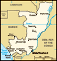
Location: Western Africa, bordering the South Atlantic Ocean, between Angola and Gabon
Geographic coordinates: 1 00 S, 15 00 E
Map references: Africa
Area: Total: 342,000 sq km land: 341,500 sq km water: 500 sq km
Area - comparative: Slightly smaller than Montana
Land boundaries: Total: 5,504 km border countries: Angola 201 km, Cameroon 523 km, Central African Republic 467 km, Democratic Republic of the Congo 2,410 km, Gabon 1,903 km
Coastline: 169 km
Maritime claims: Territorial sea: 200 nm
Climate: Tropical; rainy season (March to June); dry season (June to October); constantly high temperatures and humidity; particularly enervating climate astride the Equator
Terrain: Coastal plain, southern basin, central plateau, northern basin
Elevation extremes: Lowest point: Atlantic Ocean 0 m highest point: Mount Berongou 903 m
Natural resources: Petroleum, timber, potash, lead, zinc, uranium, copper, phosphates, gold, magnesium, natural gas, hydropower
Land use: Arable land: 0.51% permanent crops: 0.13% other: 99.36% (2001)
Irrigated land: 10 sq km (1998 est.)
Natural hazards: Seasonal flooding
Environment - current issues: Air pollution from vehicle emissions; water pollution from the dumping of raw sewage; tap water is not potable; deforestation
Environment - international agreements: Party to: Biodiversity, Climate Change, Desertification, Endangered Species, Ozone Layer Protection, Tropical Timber 83, Tropical Timber 94, Wetlands signed, but not ratified: Law of the Sea
Geography - note: About 70% of the population lives in Brazzaville, Pointe-Noire, or along the railroad between them
Advertisement
The information here has been derived from Public Domain Sources such as the CIA World Factbook. No liability can be taken for any inaccuracies.
Tot: 0.031s; Tpl: 0.007s; cc: 6; qc: 6; dbt: 0.0079s; 1; m:domysql w:travelblog (10.17.0.13); sld: 1;
; mem: 1.1mb
 Upon independence in 1960, the former French region of Middle Congo became the Republic of the Congo. A quarter century of experimentation with Marxism was abandoned in 1990 and a democratically elected government installed in 1992. A brief civil war...