Central African Geography, Central African Republic Geography
Advertisement
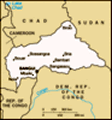
Location: Central Africa, north of Democratic Republic of the Congo
Geographic coordinates: 7 00 N, 21 00 E
Map references: Africa
Area: Total: 622,984 sq km land: 622,984 sq km water: 0 sq km
Area - comparative: Slightly smaller than Texas
Land boundaries: Total: 5,203 km border countries: Cameroon 797 km, Chad 1,197 km, Democratic Republic of the Congo 1,577 km, Republic of the Congo 467 km, Sudan 1,165 km
Coastline: 0 km (landlocked)
Maritime claims: None (landlocked)
Climate: Tropical; hot, dry winters; mild to hot, wet summers
Terrain: Vast, flat to rolling, monotonous plateau; scattered hills in northeast and southwest
Elevation extremes: Lowest point: Oubangui River 335 m highest point: Mont Ngaoui 1,420 m
Natural resources: Diamonds, uranium, timber, gold, oil, hydropower
Land use: Arable land: 3.1% permanent crops: 0.14% other: 96.76% (2001)
Irrigated land: NA sq km
Natural hazards: Hot, dry, dusty harmattan winds affect northern areas; floods are common
Environment - current issues: Tap water is not potable; poaching has diminished the country's reputation as one of the last great wildlife refuges; desertification; deforestation
Environment - international agreements: Party to: Biodiversity, Climate Change, Desertification, Endangered Species, Ozone Layer Protection, Tropical Timber 94 signed, but not ratified: Law of the Sea
Geography - note: Landlocked; almost the precise center of Africa
Advertisement
The information here has been derived from Public Domain Sources such as the CIA World Factbook. No liability can be taken for any inaccuracies.
Tot: 0.036s; Tpl: 0.008s; cc: 3; qc: 10; dbt: 0.0119s; 1; m:domysql w:travelblog (10.17.0.13); sld: 1;
; mem: 1.1mb
 The former French colony of Ubangi-Shari became the Central African Republic upon independence in 1960. After three tumultuous decades of misrule - mostly by military governments - civilian rule was established in 1993 and lasted for one decade. Pres...