Motswana (singular), Batswana (plural) Geography, Botswana Geography
Advertisement
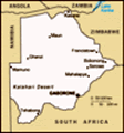
Location: Southern Africa, north of South Africa
Geographic coordinates: 22 00 S, 24 00 E
Map references: Africa
Area: Total: 600,370 sq km land: 585,370 sq km water: 15,000 sq km
Area - comparative: Slightly smaller than Texas
Land boundaries: Total: 4,013 km border countries: Namibia 1,360 km, South Africa 1,840 km, Zimbabwe 813 km
Coastline: 0 km (landlocked)
Maritime claims: None (landlocked)
Climate: Semiarid; warm winters and hot summers
Terrain: Predominantly flat to gently rolling tableland; Kalahari Desert in southwest
Elevation extremes: Lowest point: junction of the Limpopo and Shashe Rivers 513 m highest point: Tsodilo Hills 1,489 m
Natural resources: Diamonds, copper, nickel, salt, soda ash, potash, coal, iron ore, silver
Land use: Arable land: 0.65% permanent crops: 0.01% other: 99.34% (2001)
Irrigated land: 10 sq km (1998 est.)
Natural hazards: Periodic droughts; seasonal August winds blow from the west, carrying sand and dust across the country, which can obscure visibility
Environment - current issues: Overgrazing; desertification; limited fresh water resources
Environment - international agreements: Party to: Biodiversity, Climate Change, Climate Change-Kyoto Protocol, Desertification, Endangered Species, Hazardous Wastes, Law of the Sea, Ozone Layer Protection, Wetlands signed, but not ratified: none of the selected agreements
Geography - note: Landlocked; population concentrated in eastern part of the country
Advertisement
The information here has been derived from Public Domain Sources such as the CIA World Factbook. No liability can be taken for any inaccuracies.
Tot: 0.057s; Tpl: 0.008s; cc: 6; qc: 6; dbt: 0.0142s; 1; m:domysql w:travelblog (10.17.0.13); sld: 1;
; mem: 1.1mb
 Formerly the British protectorate of Bechuanaland, Botswana adopted its new name upon independence in 1966. Four decades of uninterrupted civilian leadership, progressive social policies, and significant capital investment have created one of the mos...