Ugandan Geography, Uganda Geography
Advertisement
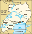
Location: Eastern Africa, west of Kenya
Geographic coordinates: 1 00 N, 32 00 E
Map references: Africa
Area: Total: 236,040 sq km land: 199,710 sq km water: 36,330 sq km
Area - comparative: Slightly smaller than Oregon
Land boundaries: Total: 2,698 km border countries: Democratic Republic of the Congo 765 km, Kenya 933 km, Rwanda 169 km, Sudan 435 km, Tanzania 396 km
Coastline: 0 km (landlocked)
Maritime claims: None (landlocked)
Climate: Tropical; generally rainy with two dry seasons (December to February, June to August); semiarid in northeast
Terrain: Mostly plateau with rim of mountains
Elevation extremes: Lowest point: Lake Albert 621 m highest point: Margherita Peak on Mount Stanley 5,110 m
Natural resources: Copper, cobalt, hydropower, limestone, salt, arable land
Land use: Arable land: 25.88% permanent crops: 10.65% other: 63.47% (2001)
Irrigated land: 90 sq km (1998 est.)
Natural hazards: NA
Environment - current issues: Draining of wetlands for agricultural use; deforestation; overgrazing; soil erosion; water hyacinth infestation in Lake Victoria; poaching is widespread
Environment - international agreements: Party to: Biodiversity, Climate Change, Climate Change-Kyoto Protocol, Desertification, Endangered Species, Hazardous Wastes, Law of the Sea, Marine Life Conservation, Ozone Layer Protection, Wetlands signed, but not ratified: Environmental Modification
Geography - note: Landlocked; fertile, well-watered country with many lakes and rivers
Advertisement
The information here has been derived from Public Domain Sources such as the CIA World Factbook. No liability can be taken for any inaccuracies.
Tot: 0.057s; Tpl: 0.007s; cc: 6; qc: 6; dbt: 0.0161s; 1; m:domysql w:travelblog (10.17.0.13); sld: 1;
; mem: 1.1mb
 Uganda achieved independence from the UK in 1962. The dictatorial regime of Idi AMIN (1971-79) was responsible for the deaths of some 300,000 opponents; guerrilla war and human rights abuses under Milton OBOTE (1980-85) claimed at least another 100,0...