Turkmen Geography, Turkmenistan Geography
Advertisement
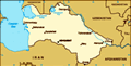
Location: Central Asia, bordering the Caspian Sea, between Iran and Kazakhstan
Geographic coordinates: 40 00 N, 60 00 E
Map references: Asia
Area: Total: 488,100 sq km land: 488,100 sq km water: negl.
Area - comparative: Slightly larger than California
Land boundaries: Total: 3,736 km border countries: Afghanistan 744 km, Iran 992 km, Kazakhstan 379 km, Uzbekistan 1,621 km
Coastline: 0 km; note - Turkmenistan borders the Caspian Sea (1,768 km)
Maritime claims: None (landlocked)
Climate: Subtropical desert
Terrain: Flat-to-rolling sandy desert with dunes rising to mountains in the south; low mountains along border with Iran; borders Caspian Sea in west
Elevation extremes: Lowest point: Vpadina Akchanaya -81 m; note - Sarygamysh Koli is a lake in northern Turkmenistan with a water level that fluctuates above and below the elevation of Vpadina Akchanaya (the lake has dropped as low as -110 m) highest point: Gora Ayribaba 3,139 m
Natural resources: Petroleum, natural gas, sulfur, salt
Land use: Arable land: 3.72% permanent crops: 0.14% other: 96.14% (2001)
Irrigated land: 17,500 sq km (2003 est.)
Natural hazards: NA
Environment - current issues: Contamination of soil and groundwater with agricultural chemicals, pesticides; salination, water-logging of soil due to poor irrigation methods; Caspian Sea pollution; diversion of a large share of the flow of the Amu Darya into irrigation contributes to that river's inability to replenish the Aral Sea; desertification
Environment - international agreements: Party to: Biodiversity, Climate Change, Climate Change-Kyoto Protocol, Desertification, Hazardous Wastes, Ozone Layer Protection signed, but not ratified: none of the selected agreements
Geography - note: Landlocked; the western and central low-lying, desolate portions of the country make up the great Garagum (Kara-Kum) desert, which occupies over 80% of the country; eastern part is plateau
Advertisement
The information here has been derived from Public Domain Sources such as the CIA World Factbook. No liability can be taken for any inaccuracies.
Tot: 0.051s; Tpl: 0.007s; cc: 5; qc: 8; dbt: 0.0084s; 1; m:domysql w:travelblog (10.17.0.13); sld: 1;
; mem: 1.1mb
 Annexed by Russia between 1865 and 1885, Turkmenistan became a Soviet republic in 1924. It achieved its independence upon the dissolution of the USSR in 1991. President NIYAZOV retains absolute control over the country and opposition is not tolerated...