Chinese/Taiwanese Geography, Taiwan Geography
Advertisement
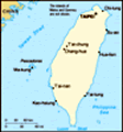
Location: Eastern Asia, islands bordering the East China Sea, Philippine Sea, South China Sea, and Taiwan Strait, north of the Philippines, off the southeastern coast of China
Geographic coordinates: 23 30 N, 121 00 E
Map references: Southeast Asia
Area: Total: 35,980 sq km land: 32,260 sq km water: 3,720 sq km note: includes the Pescadores, Matsu, and Quemoy
Area - comparative: Slightly smaller than Maryland and Delaware combined
Land boundaries: 0 km
Coastline: 1,566.3 km
Maritime claims: Territorial sea: 12 nm exclusive economic zone: 200 nm
Climate: Tropical; marine; rainy season during southwest monsoon (June to August); cloudiness is persistent and extensive all year
Terrain: Eastern two-thirds mostly rugged mountains; flat to gently rolling plains in west
Elevation extremes: Lowest point: South China Sea 0 m highest point: Yu Shan 3,952 m
Natural resources: Small deposits of coal, natural gas, limestone, marble, and asbestos
Land use: Arable land: 24% permanent crops: 1% other: 75% (2001)
Irrigated land: NA sq km
Natural hazards: Earthquakes and typhoons
Environment - current issues: Air pollution; water pollution from industrial emissions, raw sewage; contamination of drinking water supplies; trade in endangered species; low-level radioactive waste disposal
Environment - international agreements: Party to: none of the selected agreements because of Taiwan's international status signed, but not ratified: none of the selected agreements because of Taiwan's international status
Geography - note: Strategic location adjacent to both the Taiwan Strait and the Luzon Strait
Advertisement
The information here has been derived from Public Domain Sources such as the CIA World Factbook. No liability can be taken for any inaccuracies.
Tot: 0.052s; Tpl: 0.007s; cc: 6; qc: 6; dbt: 0.0087s; 1; m:domysql w:travelblog (10.17.0.13); sld: 1;
; mem: 1.1mb
 In 1895, military defeat forced China to cede Taiwan to Japan. Taiwan reverted to Chinese control after World War II. Following the Communist victory on the mainland in 1949, 2 million Nationalists fled to Taiwan and established a government using th...