Tajikistani Geography, Tajikistan Geography
Advertisement
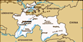
Location: Central Asia, west of China
Geographic coordinates: 39 00 N, 71 00 E
Map references: Asia
Area: Total: 143,100 sq km land: 142,700 sq km water: 400 sq km
Area - comparative: Slightly smaller than Wisconsin
Land boundaries: Total: 3,651 km border countries: Afghanistan 1,206 km, China 414 km, Kyrgyzstan 870 km, Uzbekistan 1,161 km
Coastline: 0 km (landlocked)
Maritime claims: None (landlocked)
Climate: Midlatitude continental, hot summers, mild winters; semiarid to polar in Pamir Mountains
Terrain: Pamir and Alay Mountains dominate landscape; western Fergana Valley in north, Kofarnihon and Vakhsh Valleys in southwest
Elevation extremes: Lowest point: Syr Darya (Sirdaryo) 300 m highest point: Qullai Ismoili Somoni 7,495 m
Natural resources: Hydropower, some petroleum, uranium, mercury, brown coal, lead, zinc, antimony, tungsten, silver, gold
Land use: Arable land: 6.61% permanent crops: 0.92% other: 92.47% (2001)
Irrigated land: 7,200 sq km (1998 est.)
Natural hazards: Earthquakes and floods
Environment - current issues: Inadequate sanitation facilities; increasing levels of soil salinity; industrial pollution; excessive pesticides
Environment - international agreements: Party to: Biodiversity, Climate Change, Desertification, Environmental Modification, Ozone Layer Protection, Wetlands signed, but not ratified: none of the selected agreements
Geography - note: Landlocked; mountainous region dominated by the Trans-Alay Range in the north and the Pamirs in the southeast; highest point, Qullai Ismoili Somoni (formerly Communism Peak), was the tallest mountain in the former USSR
Advertisement
The information here has been derived from Public Domain Sources such as the CIA World Factbook. No liability can be taken for any inaccuracies.
Tot: 0.171s; Tpl: 0.007s; cc: 3; qc: 2; dbt: 0.0538s; 1; m:domysql w:travelblog (10.17.0.13); sld: 1;
; mem: 1.1mb
 The Tajik people came under Russian rule in the 1860s and 1870s, but Russia's hold on Central Asia weakened following the Revolution of 1917. Bolshevik control of the area was fiercely contested and not fully reestablished until 1925. Tajikistan beca...