Somali Geography, Somalia Geography
Advertisement
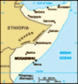
Location: Eastern Africa, bordering the Gulf of Aden and the Indian Ocean, east of Ethiopia
Geographic coordinates: 10 00 N, 49 00 E
Map references: Africa
Area: Total: 637,657 sq km land: 627,337 sq km water: 10,320 sq km
Area - comparative: Slightly smaller than Texas
Land boundaries: Total: 2,340 km border countries: Djibouti 58 km, Ethiopia 1,600 km, Kenya 682 km
Coastline: 3,025 km
Maritime claims: Territorial sea: 200 nm
Climate: Principally desert; December to February - northeast monsoon, moderate temperatures in north and very hot in south; May to October - southwest monsoon, torrid in the north and hot in the south, irregular rainfall, hot and humid periods (tangambili) between monsoons
Terrain: Mostly flat to undulating plateau rising to hills in north
Elevation extremes: Lowest point: Indian Ocean 0 m highest point: Shimbiris 2,416 m
Natural resources: Uranium and largely unexploited reserves of iron ore, tin, gypsum, bauxite, copper, salt, natural gas, likely oil reserves
Land use: Arable land: 1.67% permanent crops: 0.04% other: 98.29% (2001)
Irrigated land: 2,000 sq km (1998 est.)
Natural hazards: Recurring droughts; frequent dust storms over eastern plains in summer; floods during rainy season
Environment - current issues: Famine; use of contaminated water contributes to human health problems; deforestation; overgrazing; soil erosion; desertification
Environment - international agreements: Party to: Endangered Species, Law of the Sea, Ozone Layer Protection
Geography - note: Strategic location on Horn of Africa along southern approaches to Bab el Mandeb and route through Red Sea and Suez Canal
Advertisement
The information here has been derived from Public Domain Sources such as the CIA World Factbook. No liability can be taken for any inaccuracies.
Tot: 0.021s; Tpl: 0.007s; cc: 3; qc: 2; dbt: 0.0058s; 1; m:domysql w:travelblog (10.17.0.13); sld: 1;
; mem: 1.1mb
 The regime of Mohamed SIAD Barre was ousted in January 1991; turmoil, factional fighting, and anarchy have followed in the years since. In May of 1991, northern clans declared an independent Republic of Somaliland that now includes the administrative...