Slovenian Geography, Slovenia Geography
Advertisement
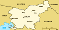
Location: Central Europe, eastern Alps bordering the Adriatic Sea, between Austria and Croatia
Geographic coordinates: 46 07 N, 14 49 E
Map references: Europe
Area: Total: 20,273 sq km land: 20,151 sq km water: 122 sq km
Area - comparative: Slightly smaller than New Jersey
Land boundaries: Total: 1,334 km border countries: Austria 330 km, Croatia 670 km, Italy 232 km, Hungary 102 km
Coastline: 46.6 km
Maritime claims: NA
Climate: Mediterranean climate on the coast, continental climate with mild to hot summers and cold winters in the plateaus and valleys to the east
Terrain: A short coastal strip on the Adriatic, an alpine mountain region adjacent to Italy and Austria, mixed mountains and valleys with numerous rivers to the east
Elevation extremes: Lowest point: Adriatic Sea 0 m highest point: Triglav 2,864 m
Natural resources: Lignite coal, lead, zinc, mercury, uranium, silver, hydropower, forests
Land use: Arable land: 8.6% permanent crops: 1.49% other: 89.91% (2001)
Irrigated land: 20 sq km (1998 est.)
Natural hazards: Flooding and earthquakes
Environment - current issues: Sava River polluted with domestic and industrial waste; pollution of coastal waters with heavy metals and toxic chemicals; forest damage near Koper from air pollution (originating at metallurgical and chemical plants) and resulting acid rain
Environment - international agreements: Party to: Air Pollution, Air Pollution-Sulfur 94, Biodiversity, Climate Change, Climate Change-Kyoto Protocol, Desertification, Endangered Species, Hazardous Wastes, Law of the Sea, Marine Dumping, Ozone Layer Protection, Ship Pollution, Wetlands signed, but not ratified: Air Pollution-Persistent Organic Pollutants
Geography - note: Despite its small size, this eastern Alpine country controls some of Europe's major transit routes
Advertisement
The information here has been derived from Public Domain Sources such as the CIA World Factbook. No liability can be taken for any inaccuracies.
Tot: 0.064s; Tpl: 0.009s; cc: 5; qc: 6; dbt: 0.0114s; 1; m:domysql w:travelblog (10.17.0.13); sld: 1;
; mem: 1.1mb
 The Slovene lands were part of the Holy Roman Empire and Austria until 1918 when the Slovenes joined the Serbs and Croats in forming a new multinational state, renamed Yugoslavia in 1929. After World War II, Slovenia became a republic of the renewed ...