Saudi or Saudi Arabian Geography, Saudi Arabia Geography
Advertisement
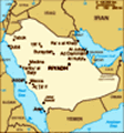
Location: Middle East, bordering the Persian Gulf and the Red Sea, north of Yemen
Geographic coordinates: 25 00 N, 45 00 E
Map references: Middle East
Area: Total: 1,960,582 sq km land: 1,960,582 sq km water: 0 sq km
Area - comparative: Slightly more than one-fifth the size of the US
Land boundaries: Total: 4,431 km border countries: Iraq 814 km, Jordan 744 km, Kuwait 222 km, Oman 676 km, Qatar 60 km, UAE 457 km, Yemen 1,458 km
Coastline: 2,640 km
Maritime claims: Territorial sea: 12 nm contiguous zone: 18 nm continental shelf: not specified
Climate: Harsh, dry desert with great temperature extremes
Terrain: Mostly uninhabited, sandy desert
Elevation extremes: Lowest point: Persian Gulf 0 m highest point: Jabal Sawda' 3,133 m
Natural resources: Petroleum, natural gas, iron ore, gold, copper
Land use: Arable land: 1.67% permanent crops: 0.09% other: 98.24% (2001)
Irrigated land: 16,200 sq km (1998 est.)
Natural hazards: Frequent sand and dust storms
Environment - current issues: Desertification; depletion of underground water resources; the lack of perennial rivers or permanent water bodies has prompted the development of extensive seawater desalination facilities; coastal pollution from oil spills
Environment - international agreements: Party to: Biodiversity, Climate Change, Climate Change-Kyoto Protocol, Desertification, Endangered Species, Hazardous Wastes, Law of the Sea, Ozone Layer Protection signed, but not ratified: none of the selected agreements
Geography - note: Extensive coastlines on Persian Gulf and Red Sea provide great leverage on shipping (especially crude oil) through Persian Gulf and Suez Canal
Advertisement
The information here has been derived from Public Domain Sources such as the CIA World Factbook. No liability can be taken for any inaccuracies.
Tot: 0.035s; Tpl: 0.008s; cc: 6; qc: 6; dbt: 0.0086s; 1; m:domysql w:travelblog (10.17.0.13); sld: 1;
; mem: 1.1mb
 In 1902, ABD AL-AZIZ bin Abd al-Rahman Al Saud captured Riyadh and set out on a 30-year campaign to unify the Arabian Peninsula. A son of ABD AL-AZIZ rules the country today, and the country's Basic Law stipulates that the throne shall remain in the ...