Surinamese Geography, Suriname Geography
Advertisement
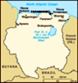
Location: Northern South America, bordering the North Atlantic Ocean, between French Guiana and Guyana
Geographic coordinates: 4 00 N, 56 00 W
Map references: South America
Area: Total: 163,270 sq km land: 161,470 sq km water: 1,800 sq km
Area - comparative: Slightly larger than Georgia
Land boundaries: Total: 1,707 km border countries: Brazil 597 km, French Guiana 510 km, Guyana 600 km
Coastline: 386 km
Maritime claims: Territorial sea: 12 nm exclusive economic zone: 200 nm
Climate: Tropical; moderated by trade winds
Terrain: Mostly rolling hills; narrow coastal plain with swamps
Elevation extremes: Lowest point: unnamed location in the coastal plain -2 m highest point: Juliana Top 1,230 m
Natural resources: Timber, hydropower, fish, kaolin, shrimp, bauxite, gold, and small amounts of nickel, copper, platinum, iron ore
Land use: Arable land: 0.37% permanent crops: 0.06% other: 99.57% (2001)
Irrigated land: 490 sq km (1998 est.)
Natural hazards: NA
Environment - current issues: Deforestation as timber is cut for export; pollution of inland waterways by small-scale mining activities
Environment - international agreements: Party to: Biodiversity, Climate Change, Desertification, Endangered Species, Law of the Sea, Marine Dumping, Ozone Layer Protection, Ship Pollution, Tropical Timber 94, Wetlands signed, but not ratified: none of the selected agreements
Geography - note: Smallest independent country on South American continent; mostly tropical rain forest; great diversity of flora and fauna that, for the most part, is increasingly threatened by new development; relatively small population, mostly along the coast
Advertisement
The information here has been derived from Public Domain Sources such as the CIA World Factbook. No liability can be taken for any inaccuracies.
Tot: 0.065s; Tpl: 0.009s; cc: 5; qc: 8; dbt: 0.0371s; 1; m:domysql w:travelblog (10.17.0.13); sld: 1;
; mem: 1mb
 Independence from the Netherlands was granted in 1975. Five years later the civilian government was replaced by a military regime that soon declared a socialist republic. It continued to rule through a succession of nominally civilian administrations...