Mozambican Geography, Mozambique Geography
Advertisement
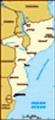
Location: South-eastern Africa, bordering the Mozambique Channel, between South Africa and Tanzania
Geographic coordinates: 18 15 S, 35 00 E
Map references: Africa
Area: Total: 801,590 sq km land: 784,090 sq km water: 17,500 sq km
Area - comparative: Slightly less than twice the size of California
Land boundaries: Total: 4,571 km border countries: Malawi 1,569 km, South Africa 491 km, Swaziland 105 km, Tanzania 756 km, Zambia 419 km, Zimbabwe 1,231 km
Coastline: 2,470 km
Maritime claims: Territorial sea: 12 nm exclusive economic zone: 200 nm
Climate: Tropical to subtropical
Terrain: Mostly coastal lowlands, uplands in center, high plateaus in northwest, mountains in west
Elevation extremes: Lowest point: Indian Ocean 0 m highest point: Monte Binga 2,436 m
Natural resources: Coal, titanium, natural gas, hydropower, tantalum, graphite
Land use: Arable land: 5.1% permanent crops: 0.3% other: 94.6% (2001)
Irrigated land: 1,070 sq km (1998 est.)
Natural hazards: Severe droughts; devastating cyclones and floods in central and southern provinces
Environment - current issues: A long civil war and recurrent drought in the hinterlands have resulted in increased migration of the population to urban and coastal areas with adverse environmental consequences; desertification; pollution of surface and coastal waters; elephant poaching for ivory is a problem
Environment - international agreements: Party to: Biodiversity, Climate Change, Climate Change-Kyoto Protocol, Desertification, Endangered Species, Hazardous Wastes, Law of the Sea, Ozone Layer Protection signed, but not ratified: none of the selected agreements
Geography - note: The Zambezi flows through the north-central and most fertile part of the country
Advertisement
The information here has been derived from Public Domain Sources such as the CIA World Factbook. No liability can be taken for any inaccuracies.
Tot: 0.032s; Tpl: 0.007s; cc: 6; qc: 6; dbt: 0.0053s; 1; m:domysql w:travelblog (10.17.0.13); sld: 1;
; mem: 1.1mb
 Almost five centuries as a Portuguese colony came to a close with independence in 1975. Large-scale emigration by whites, economic dependence on South Africa, a severe drought, and a prolonged civil war hindered the country's development. The ruling ...