Omani Geography, Oman Geography
Advertisement
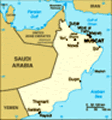
Location: Middle East, bordering the Arabian Sea, Gulf of Oman, and Persian Gulf, between Yemen and UAE
Geographic coordinates: 21 00 N, 57 00 E
Map references: Middle East
Area: Total: 212,460 sq km land: 212,460 sq km water: 0 sq km
Area - comparative: Slightly smaller than Kansas
Land boundaries: Total: 1,374 km border countries: Saudi Arabia 676 km, UAE 410 km, Yemen 288 km
Coastline: 2,092 km
Maritime claims: Territorial sea: 12 nm contiguous zone: 24 nm exclusive economic zone: 200 nm
Climate: Dry desert; hot, humid along coast; hot, dry interior; strong southwest summer monsoon (May to September) in far south
Terrain: Central desert plain, rugged mountains in north and south
Elevation extremes: Lowest point: Arabian Sea 0 m highest point: Jabal Shams 2,980 m
Natural resources: Petroleum, copper, asbestos, some marble, limestone, chromium, gypsum, natural gas
Land use: Arable land: 0.12% permanent crops: 0.14% other: 99.74% (2001)
Irrigated land: 620 sq km (1998 est.)
Natural hazards: Summer winds often raise large sandstorms and dust storms in interior; periodic droughts
Environment - current issues: Rising soil salinity; beach pollution from oil spills; very limited natural fresh water resources
Environment - international agreements: Party to: Biodiversity, Climate Change, Climate Change-Kyoto Protocol, Desertification, Hazardous Wastes, Law of the Sea, Marine Dumping, Ozone Layer Protection, Ship Pollution, Whaling signed, but not ratified: none of the selected agreements
Geography - note: Strategic location on Musandam Peninsula adjacent to Strait of Hormuz, a vital transit point for world crude oil
Advertisement
The information here has been derived from Public Domain Sources such as the CIA World Factbook. No liability can be taken for any inaccuracies.
Tot: 0.049s; Tpl: 0.009s; cc: 6; qc: 8; dbt: 0.0071s; 1; m:domysql w:travelblog (10.17.0.13); sld: 1;
; mem: 1.1mb
 In 1970, QABOOS bin Said Al Said ousted his father and has ruled as sultan ever since. His extensive modernization program has opened the country to the outside world and has preserved a long-standing political and military relationship with the UK. ...