Mauritian Geography, Mauritius Geography
Advertisement
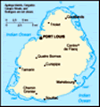
Location: Southern Africa, island in the Indian Ocean, east of Madagascar
Geographic coordinates: 20 17 S, 57 33 E
Map references: Political Map of the World
Area: Total: 2,040 sq km land: 2,030 sq km water: 10 sq km note: includes Agalega Islands, Cargados Carajos Shoals (Saint Brandon), and Rodrigues
Area - comparative: Almost 11 times the size of Washington, DC
Land boundaries: 0 km
Coastline: 177 km
Maritime claims: Territorial sea: 12 nm exclusive economic zone: 200 nm continental shelf: 200 nm or to the edge of the continental margin
Climate: Tropical, modified by southeast trade winds; warm, dry winter (May to November); hot, wet, humid summer (November to May)
Terrain: Small coastal plain rising to discontinuous mountains encircling central plateau
Elevation extremes: Lowest point: Indian Ocean 0 m highest point: Mont Piton 828 m
Natural resources: Arable land, fish
Land use: Arable land: 49.26% permanent crops: 2.96% other: 47.78% (2001)
Irrigated land: 200 sq km (2000 est.)
Natural hazards: Cyclones (November to April); almost completely surrounded by reefs that may pose maritime hazards
Environment - current issues: Water pollution, degradation of coral reefs
Environment - international agreements: Party to: Biodiversity, Climate Change, Climate Change-Kyoto Protocol, Desertification, Endangered Species, Environmental Modification, Hazardous Wastes, Law of the Sea, Marine Life Conservation, Ozone Layer Protection, Ship Pollution, Wetlands signed, but not ratified: none of the selected agreements
Geography - note: The main island, from which the country derives its name, is of volcanic origin and is almost entirely surrounded by coral reefs
Advertisement
The information here has been derived from Public Domain Sources such as the CIA World Factbook. No liability can be taken for any inaccuracies.
Tot: 0.036s; Tpl: 0.011s; cc: 5; qc: 8; dbt: 0.0068s; 1; m:domysql w:travelblog (10.17.0.13); sld: 1;
; mem: 1.1mb
 Discovered by the Portuguese in 1505, Mauritius was subsequently held by the Dutch, French, and British before independence was attained in 1968. A stable democracy with regular free elections and a positive human rights record, the country has attra...