Malian Geography, Mali Geography
Advertisement
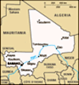
Location: Western Africa, southwest of Algeria
Geographic coordinates: 17 00 N, 4 00 W
Map references: Africa
Area: Total: 1.24 million sq km land: 1.22 million sq km water: 20,000 sq km
Area - comparative: Slightly less than twice the size of Texas
Land boundaries: Total: 7,243 km border countries: Algeria 1,376 km, Burkina Faso 1,000 km, Guinea 858 km, Cote d'Ivoire 532 km, Mauritania 2,237 km, Niger 821 km, Senegal 419 km
Coastline: 0 km (landlocked)
Maritime claims: None (landlocked)
Climate: Subtropical to arid; hot and dry February to June; rainy, humid, and mild June to November; cool and dry November to February
Terrain: Mostly flat to rolling northern plains covered by sand; savanna in south, rugged hills in northeast
Elevation extremes: Lowest point: Senegal River 23 m highest point: Hombori Tondo 1,155 m
Natural resources: Gold, phosphates, kaolin, salt, limestone, uranium, gypsum, granite, hydropower note: bauxite, iron ore, manganese, tin, and copper deposits are known but not exploited
Land use: Arable land: 3.82% permanent crops: 0.03% other: 96.15% (2001)
Irrigated land: 1,380 sq km (1998 est.)
Natural hazards: Hot, dust-laden harmattan haze common during dry seasons; recurring droughts; occasional Niger River flooding
Environment - current issues: Deforestation; soil erosion; desertification; inadequate supplies of potable water; poaching
Environment - international agreements: Party to: Biodiversity, Climate Change, Climate Change-Kyoto Protocol, Desertification, Endangered Species, Hazardous Wastes, Law of the Sea, Ozone Layer Protection, Wetlands signed, but not ratified: none of the selected agreements
Geography - note: Landlocked; divided into three natural zones: the southern, cultivated Sudanese; the central, semiarid Sahelian; and the northern, arid Saharan
Advertisement
The information here has been derived from Public Domain Sources such as the CIA World Factbook. No liability can be taken for any inaccuracies.
Tot: 0.037s; Tpl: 0.007s; cc: 4; qc: 10; dbt: 0.0101s; 1; m:domysql w:travelblog (10.17.0.13); sld: 1;
; mem: 1.1mb
 The Sudanese Republic and Senegal became independent of France in 1960 as the Mali Federation. When Senegal withdrew after only a few months, what formerly made up the Sudanese Republic was renamed Mali. Rule by dictatorship was brought to a close in...