Chinese Geography, Macau Geography
Advertisement
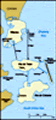
Location: Eastern Asia, bordering the South China Sea and China
Geographic coordinates: 22 10 N, 113 33 E
Map references: Southeast Asia
Area: Total: 25.4 sq km land: 25.4 sq km water: 0 sq km
Area - comparative: About 0.1 times the size of Washington, DC
Land boundaries: Total: 0.34 km regional border: China 0.34 km
Coastline: 41 km
Maritime claims: Not specified
Climate: Subtropical; marine with cool winters, warm summers
Terrain: Generally flat
Elevation extremes: Lowest point: South China Sea 0 m highest point: Coloane Alto 172.4 m
Natural resources: NEGL
Land use: Arable land: 0% permanent crops: 0% other: 100% note: "green areas" represent 22.4% (2001)
Irrigated land: NA sq km
Natural hazards: Typhoons
Environment - current issues: NA
Environment - international agreements:
Geography - note: Essentially urban; one causeway and two bridges connect the two islands of Coloane and Taipa to the peninsula on mainland
Advertisement
The information here has been derived from Public Domain Sources such as the CIA World Factbook. No liability can be taken for any inaccuracies.
Tot: 0.032s; Tpl: 0.007s; cc: 6; qc: 6; dbt: 0.0073s; 1; m:domysql w:travelblog (10.17.0.13); sld: 1;
; mem: 1.1mb
 Colonized by the Portuguese in the 16th century, Macau was the first European settlement in the Far East. Pursuant to an agreement signed by China and Portugal on 13 April 1987, Macau became the Macau Special Administrative Region (SAR) of China on 2...