Luxembourg Geography, Luxembourg Geography
Advertisement
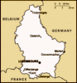
Location: Western Europe, between France and Germany
Geographic coordinates: 49 45 N, 6 10 E
Map references: Europe
Area: Total: 2,586 sq km land: 2,586 sq km water: 0 sq km
Area - comparative: Slightly smaller than Rhode Island
Land boundaries: Total: 359 km border countries: Belgium 148 km, France 73 km, Germany 138 km
Coastline: 0 km (landlocked)
Maritime claims: None (landlocked)
Climate: Modified continental with mild winters, cool summers
Terrain: Mostly gently rolling uplands with broad, shallow valleys; uplands to slightly mountainous in the north; steep slope down to Moselle flood plain in the southeast
Elevation extremes: Lowest point: Moselle River 133 m highest point: Buurgplaatz 559 m
Natural resources: Iron ore (no longer exploited), arable land
Land use: Arable land: 23.28% permanent crops: 0.4% other: 76.32% (includes Belgium) (2001)
Irrigated land: 40 sq km (includes Belgium) (1998 est.)
Natural hazards: NA
Environment - current issues: Air and water pollution in urban areas, soil pollution of farmland
Environment - international agreements: Party to: Air Pollution, Air Pollution-Nitrogen Oxides, Air Pollution-Persistent Organic Pollutants, Air Pollution-Sulfur 85, Air Pollution-Sulfur 94, Air Pollution-Volatile Organic Compounds, Biodiversity, Climate Change, Climate Change-Kyoto Protocol, Desertification, Endangered Species, Hazardous Wastes, Law of the Sea, Marine Dumping, Ozone Layer Protection, Ship Pollution, Tropical Timber 83, Tropical Timber 94, Wetlands signed, but not ratified: Environmental Modification
Geography - note: Landlocked; the only Grand Duchy in the world
Advertisement
The information here has been derived from Public Domain Sources such as the CIA World Factbook. No liability can be taken for any inaccuracies.
Tot: 0.019s; Tpl: 0.008s; cc: 3; qc: 2; dbt: 0.0028s; 1; m:domysql w:travelblog (10.17.0.13); sld: 1;
; mem: 1.1mb
 Founded in 963, Luxembourg became a grand duchy in 1815 and an independent state under the Netherlands. It lost more than half of its territory to Belgium in 1839, but gained a larger measure of autonomy. Full independence was attained in 1867. Overr...