Latvian Geography, Latvia Geography
Advertisement
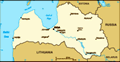
Location: Eastern Europe, bordering the Baltic Sea, between Estonia and Lithuania
Geographic coordinates: 57 00 N, 25 00 E
Map references: Europe
Area: Total: 64,589 sq km land: 63,589 sq km water: 1,000 sq km
Area - comparative: Slightly larger than West Virginia
Land boundaries: Total: 1,150 km border countries: Belarus 141 km, Estonia 339 km, Lithuania 453 km, Russia 217 km
Coastline: 531 km
Maritime claims: Territorial sea: 12 nm exclusive economic zone: 200 nm continental shelf: 200-m depth or to the depth of exploitation
Climate: Maritime; wet, moderate winters
Terrain: Low plain
Elevation extremes: Lowest point: Baltic Sea 0 m highest point: Gaizinkalns 312 m
Natural resources: Peat, limestone, dolomite, amber, hydropower, wood, arable land
Land use: Arable land: 29.67% permanent crops: 0.47% other: 69.86% (2001)
Irrigated land: 200 sq km note: land in Latvia is often too wet, and in need of drainage, not irrigation; approximately 16,000 sq km or 85% of agricultural land has been improved by drainage (1998 est.)
Natural hazards: NA
Environment - current issues: Latvia's environment has benefited from a shift to service industries after the country regained independence; the main environmental priorities are improvement of drinking water quality and sewage system, household, and hazardous waste management, as well as reduction of air pollution; in 2001, Latvia closed the EU accession negotiation chapter on environment committing to full enforcement of EU environmental directives by 2010
Environment - international agreements: Party to: Air Pollution, Air Pollution-Persistent Organic Pollutants, Biodiversity, Climate Change, Climate Change-Kyoto Protocol, Endangered Species, Hazardous Wastes, Law of the Sea, Ozone Layer Protection, Ship Pollution, Wetlands signed, but not ratified: none of the selected agreements
Geography - note: Most of the country is composed of fertile, low-lying plains, with some hills in the east
Advertisement
The information here has been derived from Public Domain Sources such as the CIA World Factbook. No liability can be taken for any inaccuracies.
Tot: 0.02s; Tpl: 0.008s; cc: 3; qc: 2; dbt: 0.0036s; 1; m:domysql w:travelblog (10.17.0.13); sld: 1;
; mem: 1.1mb
 After a brief period of independence between the two World Wars, Latvia was annexed by the USSR in 1940. It reestablished its independence in 1991 following the breakup of the Soviet Union. Although the last Russian troops left in 1994, the status of...