Lao or Laotian Geography, Laos Geography
Advertisement
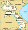
Location: Southeastern Asia, northeast of Thailand, west of Vietnam
Geographic coordinates: 18 00 N, 105 00 E
Map references: Southeast Asia
Area: Total: 236,800 sq km land: 230,800 sq km water: 6,000 sq km
Area - comparative: Slightly larger than Utah
Land boundaries: Total: 5,083 km border countries: Burma 235 km, Cambodia 541 km, China 423 km, Thailand 1,754 km, Vietnam 2,130 km
Coastline: 0 km (landlocked)
Maritime claims: None (landlocked)
Climate: Tropical monsoon; rainy season (May to November); dry season (December to April)
Terrain: Mostly rugged mountains; some plains and plateaus
Elevation extremes: Lowest point: Mekong River 70 m highest point: Phou Bia 2,817 m
Natural resources: Timber, hydropower, gypsum, tin, gold, gemstones
Land use: Arable land: 3.8% permanent crops: 0.35% other: 95.85% (2001)
Irrigated land: 1,640 sq km note: rainy season irrigation - 2,169 sq km; dry season irrigation - 750 sq km (1998 est.)
Natural hazards: Floods, droughts
Environment - current issues: Unexploded ordnance; deforestation; soil erosion; most of the population does not have access to potable water
Environment - international agreements: Party to: Biodiversity, Climate Change, Climate Change-Kyoto Protocol, Desertification, Endangered Species, Environmental Modification, Law of the Sea, Ozone Layer Protection signed, but not ratified: none of the selected agreements
Geography - note: Landlocked; most of the country is mountainous and thickly forested; the Mekong River forms a large part of the western boundary with Thailand
Advertisement
The information here has been derived from Public Domain Sources such as the CIA World Factbook. No liability can be taken for any inaccuracies.
Tot: 0.153s; Tpl: 0.007s; cc: 6; qc: 6; dbt: 0.0103s; 1; m:domysql w:travelblog (10.17.0.13); sld: 1;
; mem: 1.1mb
 Laos was under the control of Siam (Thailand) from the late 18th century until the late 19th century when it became part of French Indochina. The Franco-Siamese Treaty of 1907 defined the current Lao border with Thailand. In 1975, the Communist Pathe...