Korean Geography, North Korea Geography
Advertisement
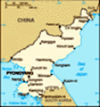
Location: Eastern Asia, northern half of the Korean Peninsula bordering the Korea Bay and the Sea of Japan, between China and South Korea
Geographic coordinates: 40 00 N, 127 00 E
Map references: Asia
Area: Total: 120,540 sq km land: 120,410 sq km water: 130 sq km
Area - comparative: Slightly smaller than Mississippi
Land boundaries: Total: 1,673 km border countries: China 1,416 km, South Korea 238 km, Russia 19 km
Coastline: 2,495 km
Maritime claims: Territorial sea: 12 nm exclusive economic zone: 200 nm note: military boundary line 50 nm in the Sea of Japan and the exclusive economic zone limit in the Yellow Sea where all foreign vessels and aircraft without permission are banned
Climate: Temperate with rainfall concentrated in summer
Terrain: Mostly hills and mountains separated by deep, narrow valleys; coastal plains wide in west, discontinuous in east
Elevation extremes: Lowest point: Sea of Japan 0 m highest point: Paektu-san 2,744 m
Natural resources: Coal, lead, tungsten, zinc, graphite, magnesite, iron ore, copper, gold, pyrites, salt, fluorspar, hydropower
Land use: Arable land: 20.76% permanent crops: 2.49% other: 76.75% (2001)
Irrigated land: 14,600 sq km (1998 est.)
Natural hazards: Late spring droughts often followed by severe flooding; occasional typhoons during the early fall
Environment - current issues: Water pollution; inadequate supplies of potable water; waterborne disease; deforestation; soil erosion and degradation
Environment - international agreements: Party to: Antarctic Treaty, Biodiversity, Climate Change, Environmental Modification, Ozone Layer Protection, Ship Pollution signed, but not ratified: Law of the Sea
Geography - note: Strategic location bordering China, South Korea, and Russia; mountainous interior is isolated and sparsely populated
Advertisement
The information here has been derived from Public Domain Sources such as the CIA World Factbook. No liability can be taken for any inaccuracies.
Tot: 0.037s; Tpl: 0.007s; cc: 6; qc: 6; dbt: 0.0096s; 1; m:domysql w:travelblog (10.17.0.13); sld: 1;
; mem: 1.1mb
 An independent kingdom under Chinese suzerainty for most of the past millennium, Korea was occupied by Japan in 1905 following the Russo-Japanese War; five years later, Japan formally annexed the entire peninsula. Following World War II, Korea was sp...