Kyrgyzstani Geography, Kyrgyzstan Geography
Advertisement
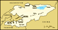
Location: Central Asia, west of China
Geographic coordinates: 41 00 N, 75 00 E
Map references: Asia
Area: Total: 198,500 sq km land: 191,300 sq km water: 7,200 sq km
Area - comparative: Slightly smaller than South Dakota
Land boundaries: Total: 3,878 km border countries: China 858 km, Kazakhstan 1,051 km, Tajikistan 870 km, Uzbekistan 1,099 km
Coastline: 0 km (landlocked)
Maritime claims: None (landlocked)
Climate: Dry continental to polar in high Tien Shan; subtropical in southwest (Fergana Valley); temperate in northern foothill zone
Terrain: Peaks of Tien Shan and associated valleys and basins encompass entire nation
Elevation extremes: Lowest point: Kara-Daryya (Karadar'ya) 132 m highest point: Jengish Chokusu (Pik Pobedy) 7,439 m
Natural resources: Abundant hydropower; significant deposits of gold and rare earth metals; locally exploitable coal, oil, and natural gas; other deposits of nepheline, mercury, bismuth, lead, and zinc
Land use: Arable land: 7.3% permanent crops: 0.35% other: 92.35% note: Kyrgyzstan has the world's largest natural growth walnut forest (2001)
Irrigated land: 10,740 sq km (1998 est.)
Natural hazards: NA
Environment - current issues: Water pollution; many people get their water directly from contaminated streams and wells; as a result, water-borne diseases are prevalent; increasing soil salinity from faulty irrigation practices
Environment - international agreements: Party to: Air Pollution, Biodiversity, Climate Change, Climate Change-Kyoto Protocol, Desertification, Hazardous Wastes, Ozone Layer Protection signed, but not ratified: none of the selected agreements
Geography - note: Landlocked; entirely mountainous, dominated by the Tien Shan range; many tall peaks, glaciers, and high-altitude lakes
Advertisement
The information here has been derived from Public Domain Sources such as the CIA World Factbook. No liability can be taken for any inaccuracies.
Tot: 0.027s; Tpl: 0.011s; cc: 3; qc: 2; dbt: 0.0049s; 1; m:domysql w:travelblog (10.17.0.13); sld: 1;
; mem: 1.1mb
 A Central Asian country of incredible natural beauty and proud nomadic traditions, Kyrgyzstan was annexed by Russia in 1864; it achieved independence from the Soviet Union in 1991. Nation-wide demonstrations in the spring of 2005 resulted in the oust...