Ivoirian Geography, Cote d’Ivoire Geography
Advertisement
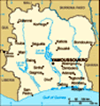
Location: Western Africa, bordering the North Atlantic Ocean, between Ghana and Liberia
Geographic coordinates: 8 00 N, 5 00 W
Map references: Africa
Area: Total: 322,460 sq km land: 318,000 sq km water: 4,460 sq km
Area - comparative: Slightly larger than New Mexico
Land boundaries: Total: 3,110 km border countries: Burkina Faso 584 km, Ghana 668 km, Guinea 610 km, Liberia 716 km, Mali 532 km
Coastline: 515 km
Maritime claims: Territorial sea: 12 nm exclusive economic zone: 200 nm continental shelf: 200 nm
Climate: Tropical along coast, semiarid in far north; three seasons - warm and dry (November to March), hot and dry (March to May), hot and wet (June to October)
Terrain: Mostly flat to undulating plains; mountains in northwest
Elevation extremes: Lowest point: Gulf of Guinea 0 m highest point: Mont Nimba 1,752 m
Natural resources: Petroleum, natural gas, diamonds, manganese, iron ore, cobalt, bauxite, copper, gold, nickel, tantalum, silica sand, clay, cocoa beans, coffee, palm oil, hydropower
Land use: Arable land: 9.75% permanent crops: 13.84% other: 76.41% (2001)
Irrigated land: 730 sq km (1998 est.)
Natural hazards: Coast has heavy surf and no natural harbors; during the rainy season torrential flooding is possible
Environment - current issues: Deforestation (most of the country's forests - once the largest in West Africa - have been heavily logged); water pollution from sewage and industrial and agricultural effluents
Environment - international agreements: Party to: Biodiversity, Climate Change, Desertification, Endangered Species, Hazardous Wastes, Law of the Sea, Marine Dumping, Ozone Layer Protection, Ship Pollution, Tropical Timber 83, Tropical Timber 94, Wetlands signed, but not ratified: none of the selected agreements
Geography - note: Most of the inhabitants live along the sandy coastal region; apart from the capital area, the forested interior is sparsely populated
Advertisement
The information here has been derived from Public Domain Sources such as the CIA World Factbook. No liability can be taken for any inaccuracies.
Tot: 0.035s; Tpl: 0.007s; cc: 5; qc: 8; dbt: 0.0097s; 1; m:domysql w:travelblog (10.17.0.13); sld: 1;
; mem: 1.1mb
 Close ties to France since independence in 1960, the development of cocoa production for export, and foreign investment made Cote d'Ivoire one of the most prosperous of the tropical African states, but did not protect it from political turmoil. On 25...