Hungarian Geography, Hungary Geography
Advertisement
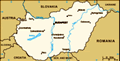
Location: Central Europe, northwest of Romania
Geographic coordinates: 47 00 N, 20 00 E
Map references: Europe
Area: Total: 93,030 sq km land: 92,340 sq km water: 690 sq km
Area - comparative: Slightly smaller than Indiana
Land boundaries: Total: 2,171 km border countries: Austria 366 km, Croatia 329 km, Romania 443 km, Serbia and Montenegro 151 km, Slovakia 677 km, Slovenia 102 km, Ukraine 103 km
Coastline: 0 km (landlocked)
Maritime claims: None (landlocked)
Climate: Temperate; cold, cloudy, humid winters; warm summers
Terrain: Mostly flat to rolling plains; hills and low mountains on the Slovakian border
Elevation extremes: Lowest point: Tisza River 78 m highest point: Kekes 1,014 m
Natural resources: Bauxite, coal, natural gas, fertile soils, arable land
Land use: Arable land: 50.09% permanent crops: 2.06% other: 47.85% (2001)
Irrigated land: 2,100 sq km (1998 est.)
Natural hazards:
Environment - current issues: The upgrading of Hungary's standards in waste management, energy efficiency, and air, soil, and water pollution to meet EU requirements will require large investments
Environment - international agreements: Party to: Air Pollution, Air Pollution-Nitrogen Oxides, Air Pollution-Persistent Organic Pollutants, Air Pollution-Sulfur 85, Air Pollution-Volatile Organic Compounds, Antarctic Treaty, Biodiversity, Climate Change, Climate Change-Kyoto Protocol, Desertification, Endangered Species, Environmental Modification, Hazardous Wastes, Law of the Sea, Marine Dumping, Ozone Layer Protection, Ship Pollution, Wetlands signed, but not ratified: Air Pollution-Sulfur 94
Geography - note: Landlocked; strategic location astride main land routes between Western Europe and Balkan Peninsula as well as between Ukraine and Mediterranean basin; the north-south flowing Duna (Danube) and Tisza Rivers divide the country into three large regions
Advertisement
The information here has been derived from Public Domain Sources such as the CIA World Factbook. No liability can be taken for any inaccuracies.
Tot: 0.062s; Tpl: 0.007s; cc: 5; qc: 8; dbt: 0.0075s; 1; m:domysql w:travelblog (10.17.0.13); sld: 1;
; mem: 1.1mb
 Hungary was part of the polyglot Austro-Hungarian Empire, which collapsed during World War I. The country fell under Communist rule following World War II. In 1956, a revolt and announced withdrawal from the Warsaw Pact were met with a massive milita...