Micronesian; Chuukese, Kosraen(s), Pohnpeian(s), Yapese Geography, Micronesia Geography
Advertisement
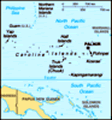
Location: Oceania, island group in the North Pacific Ocean, about three-quarters of the way from Hawaii to Indonesia
Geographic coordinates: 6 55 N, 158 15 E
Map references: Oceania
Area: Total: 702 sq km land: 702 sq km water: 0 sq km (fresh water only) note: includes Pohnpei (Ponape), Chuuk (Truk) Islands, Yap Islands, and Kosrae (Kosaie)
Area - comparative: Four times the size of Washington, DC (land area only)
Land boundaries: 0 km
Coastline: 6,112 km
Maritime claims: Territorial sea: 12 nm exclusive economic zone: 200 nm
Climate: Tropical; heavy year-round rainfall, especially in the eastern islands; located on southern edge of the typhoon belt with occasionally severe damage
Terrain: Islands vary geologically from high mountainous islands to low, coral atolls; volcanic outcroppings on Pohnpei, Kosrae, and Chuuk
Elevation extremes: Lowest point: Pacific Ocean 0 m highest point: Dolohmwar (Totolom) 791 m
Natural resources: Forests, marine products, deep-seabed minerals, phosphate
Land use: Arable land: 5.71% permanent crops: 45.71% other: 48.58% (2001)
Irrigated land: NA
Natural hazards: Typhoons (June to December)
Environment - current issues: Overfishing, climate change, pollution
Environment - international agreements: Party to: Biodiversity, Climate Change, Climate Change-Kyoto Protocol, Desertification, Hazardous Wastes, Law of the Sea, Ozone Layer Protection signed, but not ratified: none of the selected agreements
Geography - note: Four major island groups totaling 607 islands
Advertisement
The information here has been derived from Public Domain Sources such as the CIA World Factbook. No liability can be taken for any inaccuracies.
Tot: 0.041s; Tpl: 0.007s; cc: 5; qc: 8; dbt: 0.014s; 1; m:domysql w:travelblog (10.17.0.13); sld: 1;
; mem: 1mb
 In 1979 the Federated States of Micronesia, a UN Trust Territory under US administration, adopted a constitution. In 1986 independence was attained under a Compact of Free Association with the US, which was amended and renewed in 2004. Present concer...