Czech Geography, Czech Republic Geography
Advertisement
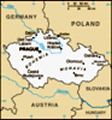
Location: Central Europe, southeast of Germany
Geographic coordinates: 49 45 N, 15 30 E
Map references: Europe
Area: Total: 78,866 sq km land: 77,276 sq km water: 1,590 sq km
Area - comparative: Slightly smaller than South Carolina
Land boundaries: Total: 1,881 km border countries: Austria 362 km, Germany 646 km, Poland 658 km, Slovakia 215 km
Coastline: 0 km (landlocked)
Maritime claims: None (landlocked)
Climate: Temperate; cool summers; cold, cloudy, humid winters
Terrain: Bohemia in the west consists of rolling plains, hills, and plateaus surrounded by low mountains; Moravia in the east consists of very hilly country
Elevation extremes: Lowest point: Elbe River 115 m highest point: Snezka 1,602 m
Natural resources: Hard coal, soft coal, kaolin, clay, graphite, timber
Land use: Arable land: 39.8% permanent crops: 3.05% other: 57.15% (2001)
Irrigated land: 240 sq km (1998 est.)
Natural hazards: Flooding
Environment - current issues: Air and water pollution in areas of northwest Bohemia and in northern Moravia around Ostrava present health risks; acid rain damaging forests; efforts to bring industry up to EU code should improve domestic pollution
Environment - international agreements: Party to: Air Pollution, Air Pollution-Nitrogen Oxides, Air Pollution-Persistent Organic Pollutants, Air Pollution-Sulfur 85, Air Pollution-Sulfur 94, Air Pollution-Volatile Organic Compounds, Antarctic Treaty, Biodiversity, Climate Change, Climate Change-Kyoto Protocol, Desertification, Endangered Species, Environmental Modification, Hazardous Wastes, Law of the Sea, Ozone Layer Protection, Ship Pollution, Wetlands signed, but not ratified: none of the selected agreements
Geography - note: Landlocked; strategically located astride some of oldest and most significant land routes in Europe; Moravian Gate is a traditional military corridor between the North European Plain and the Danube in central Europe
Advertisement
The information here has been derived from Public Domain Sources such as the CIA World Factbook. No liability can be taken for any inaccuracies.
Tot: 0.079s; Tpl: 0.007s; cc: 6; qc: 8; dbt: 0.0107s; 1; m:domysql w:travelblog (10.17.0.13); sld: 1;
; mem: 1.1mb
 Following the First World War, the closely related Czechs and Slovaks of the former Austro-Hungarian Empire merged to form Czechoslovakia. During the interwar years, the new country's leaders were frequently preoccupied with meeting the demands of ot...