Salvadoran Geography, El Salvador Geography
Advertisement
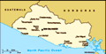
Location: Central America, bordering the North Pacific Ocean, between Guatemala and Honduras
Geographic coordinates: 13 50 N, 88 55 W
Map references: Central America and the Caribbean
Area: Total: 21,040 sq km land: 20,720 sq km water: 320 sq km
Area - comparative: Slightly smaller than Massachusetts
Land boundaries: Total: 545 km border countries: Guatemala 203 km, Honduras 342 km
Coastline: 307 km
Maritime claims: Territorial sea: 200 nm
Climate: Tropical; rainy season (May to October); dry season (November to April); tropical on coast; temperate in uplands
Terrain: Mostly mountains with narrow coastal belt and central plateau
Elevation extremes: Lowest point: Pacific Ocean 0 m highest point: Cerro El Pital 2,730 m
Natural resources: Hydropower, geothermal power, petroleum, arable land
Land use: Arable land: 31.85% permanent crops: 12.07% other: 56.08% (2001)
Irrigated land: 360 sq km (1998 est.)
Natural hazards: Known as the Land of Volcanoes; frequent and sometimes very destructive earthquakes and volcanic activity; extremely susceptible to hurricanes
Environment - current issues: Deforestation; soil erosion; water pollution; contamination of soils from disposal of toxic wastes
Environment - international agreements: Party to: Biodiversity, Climate Change, Climate Change-Kyoto Protocol, Desertification, Endangered Species, Hazardous Wastes, Ozone Layer Protection, Wetlands signed, but not ratified: Law of the Sea
Geography - note: Smallest Central American country and only one without a coastline on Caribbean Sea
Advertisement
The information here has been derived from Public Domain Sources such as the CIA World Factbook. No liability can be taken for any inaccuracies.
Tot: 0.045s; Tpl: 0.008s; cc: 6; qc: 6; dbt: 0.0081s; 1; m:domysql w:travelblog (10.17.0.13); sld: 1;
; mem: 1.1mb
 El Salvador achieved independence from Spain in 1821 and from the Central American Federation in 1839. A 12-year civil war, which cost about 75,000 lives, was brought to a close in 1992 when the government and leftist rebels signed a treaty that prov...