Equatorial Guinean or Equatoguinean Geography, Equatorial Guinea Geography
Advertisement
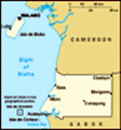
Location: Western Africa, bordering the Bight of Biafra, between Cameroon and Gabon
Geographic coordinates: 2 00 N, 10 00 E
Map references: Africa
Area: Total: 28,051 sq km land: 28,051 sq km water: 0 sq km
Area - comparative: Slightly smaller than Maryland
Land boundaries: Total: 539 km border countries: Cameroon 189 km, Gabon 350 km
Coastline: 296 km
Maritime claims: Territorial sea: 12 nm exclusive economic zone: 200 nm
Climate: Tropical; always hot, humid
Terrain: Coastal plains rise to interior hills; islands are volcanic
Elevation extremes: Lowest point: Atlantic Ocean 0 m highest point: Pico Basile 3,008 m
Natural resources: Petroleum, natural gas, timber, gold, bauxite, diamonds, tantalum, sand and gravel, clay
Land use: Arable land: 4.63% permanent crops: 3.57% other: 91.8% (2001)
Irrigated land: NA sq km
Natural hazards: Violent windstorms, flash floods
Environment - current issues: Tap water is not potable; deforestation
Environment - international agreements: Party to: Biodiversity, Climate Change, Climate Change-Kyoto Protocol, Desertification, Endangered Species, Hazardous Wastes, Law of the Sea, Ship Pollution signed, but not ratified: none of the selected agreements
Geography - note: Insular and continental regions rather widely separated
Advertisement
The information here has been derived from Public Domain Sources such as the CIA World Factbook. No liability can be taken for any inaccuracies.
Tot: 0.03s; Tpl: 0.008s; cc: 6; qc: 6; dbt: 0.0074s; 1; m:domysql w:travelblog (10.17.0.13); sld: 1;
; mem: 1.1mb
 Equatorial Guinea gained independence in 1968 after 190 years of Spanish rule. This tiny country, composed of a mainland portion plus five inhabited islands, is one of the smallest on the African continent. President OBIANG NGUEMA MBASOGO has ruled t...