Cuban Geography, Cuba Geography
Advertisement
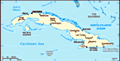
Location: Caribbean, island between the Caribbean Sea and the North Atlantic Ocean, 150 km south of Key West, Florida
Geographic coordinates: 21 30 N, 80 00 W
Map references: Central America and the Caribbean
Area: Total: 110,860 sq km land: 110,860 sq km water: 0 sq km
Area - comparative: Slightly smaller than Pennsylvania
Land boundaries: Total: 29 km border countries: US Naval Base at Guantanamo Bay 29 km note: Guantanamo Naval Base is leased by the US and thus remains part of Cuba
Coastline: 3,735 km
Maritime claims: Territorial sea: 12 nm exclusive economic zone: 200 nm
Climate: Tropical; moderated by trade winds; dry season (November to April); rainy season (May to October)
Terrain: Mostly flat to rolling plains, with rugged hills and mountains in the southeast
Elevation extremes: Lowest point: Caribbean Sea 0 m highest point: Pico Turquino 2,005 m
Natural resources: Cobalt, nickel, iron ore, chromium, copper, salt, timber, silica, petroleum, arable land
Land use: Arable land: 33.05% permanent crops: 7.6% other: 59.35% (2001)
Irrigated land: 870 sq km (1998 est.)
Natural hazards: The east coast is subject to hurricanes from August to November (in general, the country averages about one hurricane every other year); droughts are common
Environment - current issues: Air and water pollution; biodiversity loss; deforestation
Environment - international agreements: Party to: Antarctic Treaty, Biodiversity, Climate Change, Climate Change-Kyoto Protocol, Desertification, Endangered Species, Environmental Modification, Hazardous Wastes, Law of the Sea, Marine Dumping, Ozone Layer Protection, Ship Pollution, Wetlands signed, but not ratified: Marine Life Conservation
Geography - note: Largest country in Caribbean and westernmost island of the Greater Antilles
Advertisement
The information here has been derived from Public Domain Sources such as the CIA World Factbook. No liability can be taken for any inaccuracies.
Tot: 0.021s; Tpl: 0.011s; cc: 3; qc: 2; dbt: 0.0019s; 1; m:domysql w:travelblog (10.17.0.13); sld: 1;
; mem: 1.1mb
 The native Amerindian population of Cuba began to decline after the European discovery of the island by Christopher COLUMBUS in 1492 and following its development as a Spanish colony during the next several centuries. Large numbers of African slaves ...