Costa Rican Geography, Costa Rica Geography
Advertisement
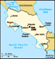
Location: Central America, bordering both the Caribbean Sea and the North Pacific Ocean, between Nicaragua and Panama
Geographic coordinates: 10 00 N, 84 00 W
Map references: Central America and the Caribbean
Area: Total: 51,100 sq km land: 50,660 sq km water: 440 sq km note: includes Isla del Coco
Area - comparative: Slightly smaller than West Virginia
Land boundaries: Total: 639 km border countries: Nicaragua 309 km, Panama 330 km
Coastline: 1,290 km
Maritime claims: Territorial sea: 12 nm exclusive economic zone: 200 nm continental shelf: 200 nm
Climate: Tropical and subtropical; dry season (December to April); rainy season (May to November); cooler in highlands
Terrain: Coastal plains separated by rugged mountains including over 100 volcanic cones, of which several are major volcanoes
Elevation extremes: Lowest point: Pacific Ocean 0 m highest point: Cerro Chirripo 3,810 m
Natural resources: Hydropower
Land use: Arable land: 4.41% permanent crops: 5.88% other: 89.71% (2001)
Irrigated land: 1,260 sq km (1998 est.)
Natural hazards: Occasional earthquakes, hurricanes along Atlantic coast; frequent flooding of lowlands at onset of rainy season and landslides; active volcanoes
Environment - current issues: Deforestation and land use change, largely a result of the clearing of land for cattle ranching and agriculture; soil erosion; coastal marine pollution; fisheries protection; solid waste management; air pollution
Environment - international agreements: Party to: Biodiversity, Climate Change, Climate Change-Kyoto Protocol, Desertification, Endangered Species, Environmental Modification, Hazardous Wastes, Law of the Sea, Marine Dumping, Ozone Layer Protection, Wetlands, Whaling signed, but not ratified: Marine Life Conservation
Geography - note: Four volcanoes, two of them active, rise near the capital of San Jose in the center of the country; one of the volcanoes, Irazu, erupted destructively in 1963-65
Advertisement
The information here has been derived from Public Domain Sources such as the CIA World Factbook. No liability can be taken for any inaccuracies.
Tot: 0.021s; Tpl: 0.007s; cc: 3; qc: 2; dbt: 0.0039s; 1; m:domysql w:travelblog (10.17.0.13); sld: 1;
; mem: 1.1mb
 Costa Rica is a Central American success story: since the late 19th century, only two brief periods of violence have marred its democratic development. Although still a largely agricultural country, it has expanded its economy to include strong techn...