Belarusian Geography, Belarus Geography
Advertisement
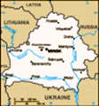
Location: Eastern Europe, east of Poland
Geographic coordinates: 53 00 N, 28 00 E
Map references: Europe
Area: Total: 207,600 sq km land: 207,600 sq km water: 0 sq km
Area - comparative: Slightly smaller than Kansas
Land boundaries: Total: 2,900 km border countries: Latvia 141 km, Lithuania 502 km, Poland 407 km, Russia 959 km, Ukraine 891 km
Coastline: 0 km (landlocked)
Maritime claims: None (landlocked)
Climate: Cold winters, cool and moist summers; transitional between continental and maritime
Terrain: Generally flat and contains much marshland
Elevation extremes: Lowest point: Nyoman River 90 m highest point: Dzyarzhynskaya Hara 346 m
Natural resources: Forests, peat deposits, small quantities of oil and natural gas, granite, dolomitic limestone, marl, chalk, sand, gravel, clay
Land use: Arable land: 29.55% permanent crops: 0.6% other: 69.85% (2001)
Irrigated land: 1,150 sq km (1998 est.)
Natural hazards: NA
Environment - current issues: Soil pollution from pesticide use; southern part of the country contaminated with fallout from 1986 nuclear reactor accident at Chornobyl' in northern Ukraine
Environment - international agreements: Party to: Air Pollution, Air Pollution-Nitrogen Oxides, Air Pollution-Sulfur 85, Biodiversity, Climate Change, Desertification, Endangered Species, Environmental Modification, Hazardous Wastes, Marine Dumping, Ozone Layer Protection, Ship Pollution, Wetlands signed, but not ratified: Law of the Sea
Geography - note: Landlocked; glacial scouring accounts for the flatness of Belarusian terrain and for its 11,000 lakes; the country is geologically well endowed with extensive deposits of granite, dolomitic limestone, marl, chalk, sand, gravel, and clay
Advertisement
The information here has been derived from Public Domain Sources such as the CIA World Factbook. No liability can be taken for any inaccuracies.
Tot: 0.035s; Tpl: 0.009s; cc: 3; qc: 2; dbt: 0.0102s; 1; m:domysql w:travelblog (10.17.0.13); sld: 1;
; mem: 1.1mb
 After seven decades as a constituent republic of the USSR, Belarus attained its independence in 1991. It has retained closer political and economic ties to Russia than any of the other former Soviet republics. Belarus and Russia signed a treaty on a ...