Bosnian, Herzegovinian Geography, Bosnia and Herzegovina Geography
Advertisement
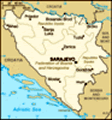
Location: Southeastern Europe, bordering the Adriatic Sea and Croatia
Geographic coordinates: 44 00 N, 18 00 E
Map references: Europe
Area: Total: 51,129 sq km land: 51,129 sq km water: 0 sq km
Area - comparative: Slightly smaller than West Virginia
Land boundaries: Total: 1,459 km border countries: Croatia 932 km, Serbia and Montenegro 527 km
Coastline: 20 km
Maritime claims: No data available
Climate: Hot summers and cold winters; areas of high elevation have short, cool summers and long, severe winters; mild, rainy winters along coast
Terrain: Mountains and valleys
Elevation extremes: Lowest point: Adriatic Sea 0 m highest point: Maglic 2,386 m
Natural resources: Coal, iron ore, bauxite, copper, lead, zinc, chromite, cobalt, manganese, nickel, clay, gypsum, salt, sand, forests, hydropower
Land use: Arable land: 13.6% permanent crops: 2.96% other: 83.44% (2001)
Irrigated land: 20 sq km (1998 est.)
Natural hazards: Destructive earthquakes
Environment - current issues: Air pollution from metallurgical plants; sites for disposing of urban waste are limited; water shortages and destruction of infrastructure because of the 1992-95 civil strife; deforestation
Environment - international agreements: Party to: Air Pollution, Biodiversity, Climate Change, Hazardous Wastes, Law of the Sea, Marine Life Conservation, Ozone Layer Protection, Wetlands signed, but not ratified: none of the selected agreements
Geography - note: Within Bosnia and Herzegovina's recognized borders, the country is divided into a joint Bosniak/Croat Federation (about 51% of the territory) and the Bosnian Serb-led Republika Srpska or RS (about 49% of the territory); the region called Herzegovina is contiguous to Croatia and Serbia and Montenegro (Montenegro), and traditionally has been settled by an ethnic Croat majority in the west and an ethnic Serb majority in the east
Advertisement
The information here has been derived from Public Domain Sources such as the CIA World Factbook. No liability can be taken for any inaccuracies.
Tot: 0.023s; Tpl: 0.007s; cc: 3; qc: 2; dbt: 0.0047s; 1; m:domysql w:travelblog (10.17.0.13); sld: 2;
; mem: 1.1mb
 Bosnia and Herzegovina's declaration of sovereignty in October 1991, was followed by a declaration of independence from the former Yugoslavia on 3 March 1992 after a referendum boycotted by ethnic Serbs. The Bosnian Serbs - supported by neighboring S...