Armenian Geography, Armenia Geography
Advertisement
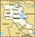
Location: Southwestern Asia, east of Turkey
Geographic coordinates: 40 00 N, 45 00 E
Map references: Asia
Area: Total: 29,800 sq km land: 28,400 sq km water: 1,400 sq km
Area - comparative: Slightly smaller than Maryland
Land boundaries: Total: 1,254 km border countries: Azerbaijan-proper 566 km, Azerbaijan-Naxcivan exclave 221 km, Georgia 164 km, Iran 35 km, Turkey 268 km
Coastline: 0 km (landlocked)
Maritime claims: None (landlocked)
Climate: Highland continental, hot summers, cold winters
Terrain: Armenian Highland with mountains; little forest land; fast flowing rivers; good soil in Aras River valley
Elevation extremes: Lowest point: Debed River 400 m highest point: Aragats Lerrnagagat' 4,090 m
Natural resources: Small deposits of gold, copper, molybdenum, zinc, alumina
Land use: Arable land: 17.55% permanent crops: 2.3% other: 80.15% (2001)
Irrigated land: 2,870 sq km (1998 est.)
Natural hazards: Occasionally severe earthquakes; droughts
Environment - current issues: Soil pollution from toxic chemicals such as DDT; the energy crisis of the 1990s led to deforestation when citizens scavenged for firewood; pollution of Hrazdan (Razdan) and Aras Rivers; the draining of Sevana Lich (Lake Sevan), a result of its use as a source for hydropower, threatens drinking water supplies; restart of Metsamor nuclear power plant in spite of its location in a seismically active zone
Environment - international agreements: Party to: Air Pollution, Biodiversity, Climate Change, Climate Change-Kyoto Protocol, Desertification, Hazardous Wastes, Law of the Sea, Ozone Layer Protection, Wetlands signed, but not ratified: Air Pollution-Persistent Organic Pollutants
Geography - note: Landlocked in the Lesser Caucasus Mountains; Sevana Lich (Lake Sevan) is the largest lake in this mountain range
Advertisement
The information here has been derived from Public Domain Sources such as the CIA World Factbook. No liability can be taken for any inaccuracies.
Tot: 0.056s; Tpl: 0.007s; cc: 6; qc: 6; dbt: 0.0301s; 1; m:domysql w:travelblog (10.17.0.13); sld: 1;
; mem: 1.1mb
 Armenia prides itself on being the first nation to formally adopt Christianity (early 4th century). Despite periods of autonomy, over the centuries Armenia came under the sway of various empires including the Roman, Byzantine, Arab, Persian, and Otto...