Advertisement
Published: October 13th 2009
We headed to TLG a few days later than planned on october 10th... Lijiang has a way of sucking you in for a while, in a good way though.
From Lijiang we took a bus to Qaitou, which is about two hours away. It costs 20 yuan if you go to the long distance bus station - just ignore all the tour guides trying to sell 200 yuan + trips. We got to Qaitou at 10:30 am after a 2 1/2 hour bus ride, and went to Jane's guest house to store our bags, and eat breakfast. Breakfast was HUGE, we could have split one entree, but it was cheap and a good start to the hike.
We had two maps for TLG that we'd picked up from different places in lijiang (one from Mama Naxi's and one from Lamu's). Each one seemed to be sponsored by different guest houses, with some other variations as well. One map said to leave our bags at Jane's, and end the trek at Tina's. The other said to leave our bags at Martha's and end at Sean's. The maps were similar, but both clearly not to scale, and other differences like one calling out the "24 bends" and the other calling it the "28 bends". We kept both maps as reference, but decided on the Janes/Tina's option (Sorry Martha and Sean, maybe next time).
I took a picture of the instructions printed on a big banner at Jane's, and we set out at 11:45 am. The instructions basically said when to leave the main road, and after that just follow the red arrows, but I took the picture just to be safe. We'd been told it would take 8 hours to hike to the Teahorse guest house, which is where we were planning on staying, so we set off at a brisk pace. We soon left the road and took off on the trail.
I'd read accounts of people getting lost trying to find the trail, but we had no problems. Many of the red arrows were freshly painted, so I could see how maybe it would have been a problem in the past. There were definitely lots of forks in the trails, since the local farmers get around mainly by horse in many areas, and the trail splits up and down the mountain. There were a couple times along the way where we had to stop and look around, but it didn't take long to find the arrows. Also in many places, the guest houses wrote short advertisements in red paint on the rocks to try to get you to stay there. "Hot water 24 hours, best view, Naxi family guest house" - stuff like that. I think Naxi family guest house is probably responsible for many of the arrows - on the way there all the arrows pointed towards them, and leaving most of the arrows pointed back. Sean's guest house has a clever marketing campaign - they use yellow arrows and paint for their ads. Luckily sean's is the same direction as Tina's until the very end, so we had a redundant check to follow.
We stopped at Naxi family for a quick rest, then proceeded the rest of the way to Teahorse. Both steph and I agreed that the 28 bends (or 24 bends, whichever map you believe) was not nearly as hard as we thought. Sure, there were a lot of switchbacks, but many of them were short, and it was not THAT steep. It was almost anticlimactic when we got to the top. After the 28 bends, it is downhill to Teahorse.
We got to Teahorse at 4:30, meaning it took less than 5 hours, even with a decent stop at Naxi family. We would have had enough daylight to continue to the Halfway house, but the view from teahorse was so good that we didn't want to leave. Besides, they had hot water and american toilets so steph was happy (yes it has come to that).
In the morning we hiked to Halfway house for breakfast. It turns out the view is just as good there. I guess when you're on the edge of a gorge with a river below and tall mountains above, the view is good anywhere. Halfway house has a few neighbors though, as opposed to the teahorse which is isolated, so we were glad with our decision to stay at teahorse.
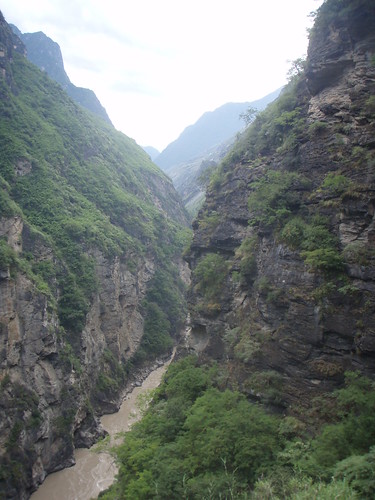
The trail between the halfway house and Tina's had the best views of the whole hike. The gorge is steepest in this area, so most of the time there is a near vertical cliff down to your right. It is so steep that trees cannot grow, so there is nothing to block the view of the river below, and mountains on the other side (contrary to the previous day, where often bamboo and pine trees blocked the view). There were also several waterfalls along the trail, and you'd have to step across rocks to make it across without getting wet. I think 75% of our pictures are from the 3 hour hike between halfway house and tina's.
We got to tina's with plenty of energy and time. It was before noon when we arrived, and we had until 4 pm to catch a bus from there to lijiang (with a stop at Jane's to pick up our bags). So we decided to hike down to the water level, and back up, which was supposed to be a 3 hour trip.
The hike down and back ended up being the most challenging part of the trek, by far. I'd say tina's is a good 1/4 mile above the water, and pretty straight down at that. The trail down was crowded with chinese tourists (we had bad timing - just after a tour bus) so we were worried about the time for our return up. We spent a little while at the river, though. I was really impressed by the power of the river and the whitewater, but steph was not impressed because the water was brown instead of blue. Go figure.
There were 3 ways to get back to tina's: back the way we came, which was packed with tourists starting the slow ascent, a long trail toward's walnut garden / sean's guest house (which would have been great if we had the time), or the "ladder" trail, which pops out just next to Tina's. We chose the ladder trail. It was the hardest hour of the trek, and probably the second hardest stretch of any hike I've done besides the switchbacks going up halfdome. There are only two ladders, the rest is extremely steep stairs. We made it back in time, but it was pretty tiring. I think steph wished she had stayed at Tina's.
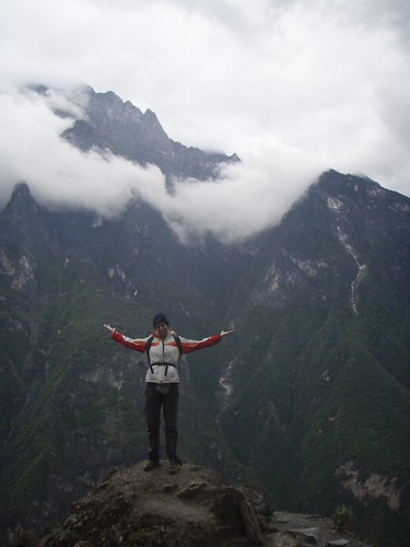
All in all a great trek, I wouldn't change anything if we could do it again. We took over 200 pictures between us, here are just a few.


Advertisement
Tot: 0.125s; Tpl: 0.009s; cc: 11; qc: 49; dbt: 0.0579s; 1; m:domysql w:travelblog (10.17.0.13); sld: 1;
; mem: 1.1mb


Matt Potterton
non-member comment
Wow
That place looks amazing!