Paraguayan Geography, Paraguay Geography
Advertisement
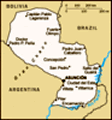
Location: Central South America, northeast of Argentina
Geographic coordinates: 23 00 S, 58 00 W
Map references: South America
Area: Total: 406,750 sq km land: 397,300 sq km water: 9,450 sq km
Area - comparative: Slightly smaller than California
Land boundaries: Total: 3,920 km border countries: Argentina 1,880 km, Bolivia 750 km, Brazil 1,290 km
Coastline: 0 km (landlocked)
Maritime claims: None (landlocked)
Climate: Subtropical to temperate; substantial rainfall in the eastern portions, becoming semiarid in the far west
Terrain: Grassy plains and wooded hills east of Rio Paraguay; Gran Chaco region west of Rio Paraguay mostly low, marshy plain near the river, and dry forest and thorny scrub elsewhere
Elevation extremes: Lowest point: junction of Rio Paraguay and Rio Parana 46 m highest point: Cerro Pero (Cerro Tres Kandu) 842 m
Natural resources: Hydropower, timber, iron ore, manganese, limestone
Land use: Arable land: 7.6% permanent crops: 0.23% other: 92.17% (2001)
Irrigated land: 670 sq km (1998 est.)
Natural hazards: Local flooding in southeast (early September to June); poorly drained plains may become boggy (early October to June)
Environment - current issues: Deforestation; water pollution; inadequate means for waste disposal pose health risks for many urban residents; loss of wetlands
Environment - international agreements: Party to: Biodiversity, Climate Change, Climate Change-Kyoto Protocol, Desertification, Endangered Species, Hazardous Wastes, Law of the Sea, Ozone Layer Protection, Wetlands signed, but not ratified: none of the selected agreements
Geography - note: Landlocked; lies between Argentina, Bolivia, and Brazil; population concentrated in southern part of country
Advertisement
The information here has been derived from Public Domain Sources such as the CIA World Factbook. No liability can be taken for any inaccuracies.
Tot: 0.018s; Tpl: 0.007s; cc: 3; qc: 2; dbt: 0.0016s; 1; m:domysql w:travelblog (10.17.0.13); sld: 1;
; mem: 1mb
 In the disastrous War of the Triple Alliance (1865-70), Paraguay lost two-thirds of all adult males and much of its territory. It stagnated economically for the next half century. In the Chaco War of 1932-35, large, economically important areas were ...